|
|
Post by stu on Aug 11, 2008 10:59:12 GMT 12
Lastly Dave I have a new system where I can map my flight with the GPS and save it in Goggle earth... Impressive  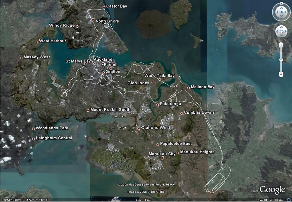 |
|
|
|
Post by Bruce on Aug 11, 2008 11:06:17 GMT 12
One of these days he'll work out how to fly straight lines!  |
|
|
|
Post by Citabria on Aug 11, 2008 11:14:26 GMT 12
Anyone can fly straight! It takes real skill to never fly straight!
I think it's amazing how using Google Earth you can zoom in and see the hangar and the fields etc... Gunna have heaps of fun playing with that.
|
|
|
|
Post by Bruce on Aug 11, 2008 11:34:27 GMT 12
Do you have the trace from our flight?
|
|
|
|
Post by Citabria on Aug 11, 2008 11:43:11 GMT 12
No, I have to take another Garmin GPS along (I'm borrowing a 296), one with a USB connection. I can next time if you like.
|
|
|
|
Post by Peter Lewis on Aug 11, 2008 12:38:39 GMT 12
KML file is a Google earth file, KMZ is a zipped KML file - which is why you get that result.
|
|
|
|
Post by Citabria on Aug 11, 2008 13:31:28 GMT 12
Ahhh I see...
|
|
|
|
Post by Dave Homewood on Aug 11, 2008 13:48:37 GMT 12
Interesting stuff. I couldn't get the link to open, so thanks for posting the picture Stu. Some of those places in Auckland I've never even heard of before.
|
|
|
|
Post by Citabria on Aug 11, 2008 14:26:12 GMT 12
You need to have Google Earth installed for it to work properly.
|
|
|
|
Post by Dave Homewood on Aug 11, 2008 19:07:10 GMT 12
Ahah. I don't have Google Earth. Joe, it would certainly be optimistic to expect a score of 2 points, that's impossible in rugby nowawdays.  |
|
|
|
Post by hardyakka on Aug 11, 2008 21:50:46 GMT 12
What's even cooler is when you get Andrew's track into Google Earth, change your viewing angle to 45deg (instead of straight overhead) you can play it as a tour and get to follow the flight along as if you were sitting in the back of CIT.
It helps to have a really fast internet connection (unlike mine) as the scenery can't keep up with the flight.
Andrew, does your software pick up the Z (altitude) component from your GPS log? If so, you should be able to see the altitude profile..... Hmmm. Perhaps that's not so smart...
|
|
|
|
Post by Citabria on Aug 12, 2008 7:27:16 GMT 12
Yes it does pick up the Z.. If you zoom down you can go below the flight path although I'm not sure that you actually get a readout... All our altitudes are on radar and I'm very careful not to go below the minimum height as you can read the 5 and 7ftr's for miles so there is no reason to get down low... the most important factor when towing banners is to have a field ready to land in if you have an engine failure. Luckily CIT is a group one and could easily land in any football field or golf course  |
|
|
|
Post by Bruce on Aug 12, 2008 8:40:09 GMT 12
I tried the "tour" last night, setting the angle to 80 deg and the view distance (altitude) to minimum and noted that it followed the expected altitude profile plus about 300 ft. The only thing is unbanked turns are pretty awkward and the effect is a bit Nauseating!
|
|
|
|
Post by Dave Homewood on Aug 12, 2008 18:57:01 GMT 12
Could, or do, they use this sort of technology to help judge precision flying competitions?
|
|
|
|
Post by hardyakka on Aug 12, 2008 21:25:57 GMT 12
This stuff is ideal for Precision Flying. The world champs were recently held in Ried, Austria. We had a small team competing. I'll ask them if they got to see any track visualisations as part of the post-flight debrief. They used to have custom software for the GPS tracking but I don't know if they use Google Earth. Even if the NZPFRA had the GPS units, we would probably still back them up with human eye judging. P.S. Andrew, I wasn't accusing you of anything. But even so, I'd worry about CAA trawling through these sorts of publicly posted files looking to fish up infringements to ping pilots with P.P.S. I managed to get the track to show altitude. All I had to do was change the default altitude setting from "Clamped to Ground" to "Absolute". Looks really cool now. |
|
|
|
Post by Citabria on Aug 13, 2008 7:52:10 GMT 12
No worries, I knew you weren't however I'm always careful to stay well within the rules, and try and set an example for my students.
The GPS stuff is really simple and free... might be worth a new topic if you want to know the secrets.
|
|
|
|
Post by b10m on Aug 13, 2008 9:54:20 GMT 12
I followed your run on google flight sim in the sr22
At one stage just out of Ardmore the trace line went through a hill
veeeery interesting.
|
|
|
|
Post by Dave Homewood on Aug 13, 2008 15:03:48 GMT 12
Unrelated queries about height restrictions, I realise there is an area around airports that allow lower flying so the aircraft can get up and down but does this have a specific boundary that it strectes to, say in certain amount of km's and then the 500 feet restriction clicks in? If so, how far off the end of the runway is the low flying zone?
Also is there a height restriction while flying over the sea that pilots must not come lower than?
|
|
|
|
Post by FlyingKiwi on Aug 13, 2008 19:08:56 GMT 12
The weather on Sunday was really fantastic, a friend and I took a 172 over to Tauranga and Pauanui Beach where there seemed to be some sort of gathering taking place:  |
|
|
|
Post by hardyakka on Aug 13, 2008 20:46:03 GMT 12
Aha! That's where the Te Kowhai crew went on Sunday. I had to drive to a family gathering that day (looking out the car window and grumbling at missing out on the best flying weather in months). I can see Matt's 150, Andy's Sportcruiser, Alan's 152 and Noel's Jodel in that photo. (and it might be Scott in the Tomahawk). Would have been a great day for it. No doubt they'll rub my nose in it at after-work-drinks on Friday for missing out on that trip. Weather will probably be shite this weekend, just to cheer me up even more...  My understanding of the rules about altitude around airports is that you can only go low if you are in the actual process of landing or taking off.Just because you are flying near an airport doesn't mean you can buzz the aero club. Other than that there are no formal distance/height graduations as you get further away. I suspect it would be too hard to take into account the performance limitations of all aircraft to make meaningful hard-and-fast rules. What might be a doddle climb out gradient for a Yak might be a real struggle for a heavily laden Tomahawk. I haven't read the exact wording of the regs for a while now, but minimum altitude over built up areas is generally taken as 1000' agl and 500' agl over sparsely populated areas (and the sea). Although I do recall a clause about keeping the ability to glide clear of any obstacles. Any professional pilots care to elaborate further? |
|