|
|
Post by baronbeeza on Sept 30, 2011 0:21:40 GMT 12
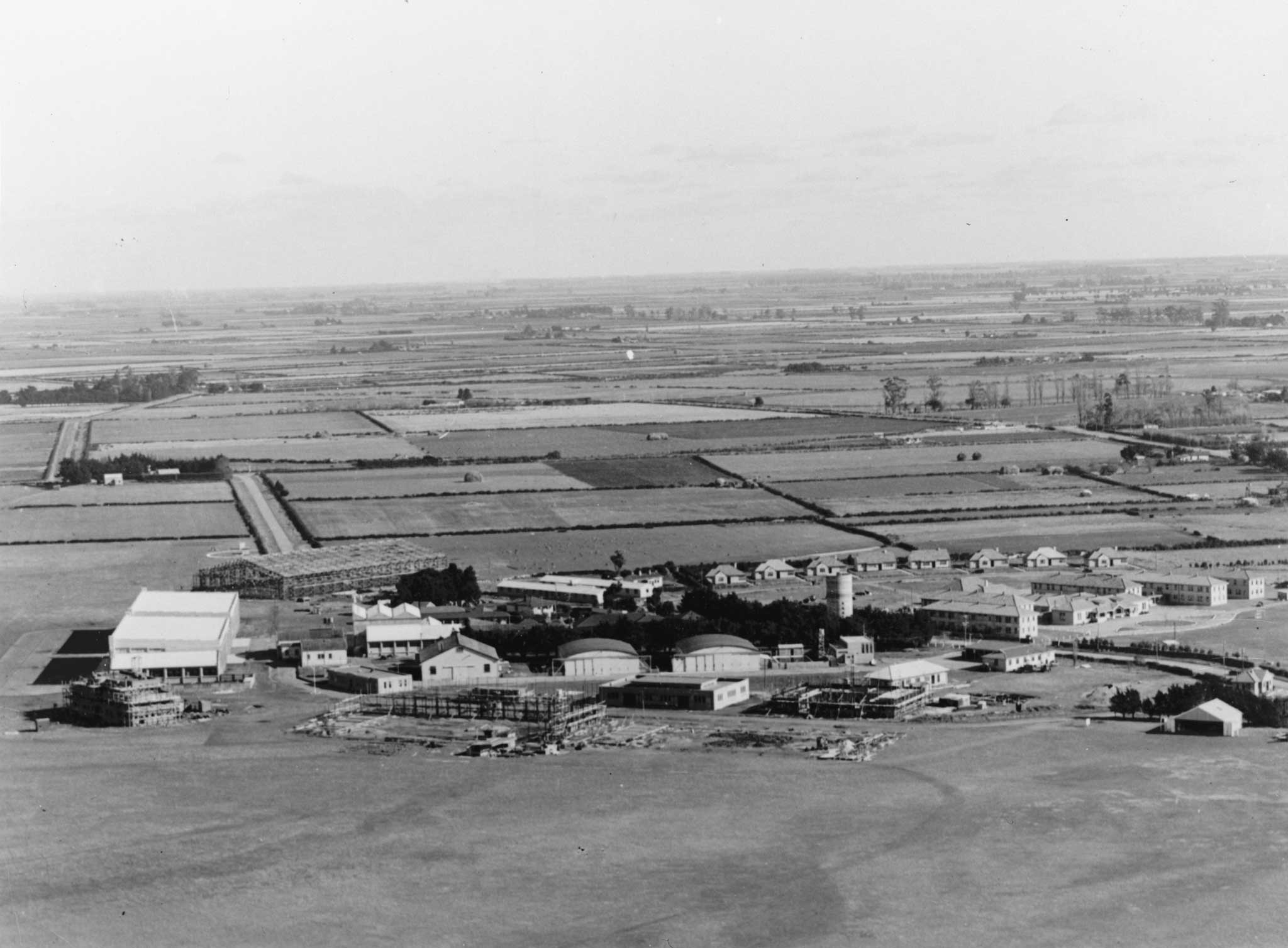
cantage.files.wordpress.com/2010/10/mus00045-copy.jpg Construction of early hangars at Wigram. Low level oblique of Royal New Zealand Air Force Station Wigram. Control tower is almost finished, framework of 6 hangar is erected and 3 hangar and 2 store are under construction. Circa April 1939 I have seen later pics of the Wigram hangars taken pre-war but this one is very good. Apologies if it has been seen here before. It sure means something to me, I reckon others will enjoy it also. I can dig out the other if required.
|
|
|
|
Post by Tony on Sept 30, 2011 0:38:08 GMT 12
Outstanding.
Thanks for posting - yep means a lot to me.
Especially with what has been lost there lately - with the re-development not the earthquake
|
|
|
|
Post by Dave Homewood on Sept 30, 2011 1:01:26 GMT 12
Beautiful shot, thanks for that. I love it. And yes it means a lot to me too.
By the way, at that time the tiny wee hangar on the far right was No. 6 Hangar. Does anyone know when that little hangar disappeared?
|
|
|
|
Post by Dave Homewood on Sept 30, 2011 1:03:34 GMT 12
You look at all those green fields (now under a sea of houses) and it could be East Anglia, so flat and perfect.
|
|
|
|
Post by baronbeeza on Sept 30, 2011 7:50:23 GMT 12
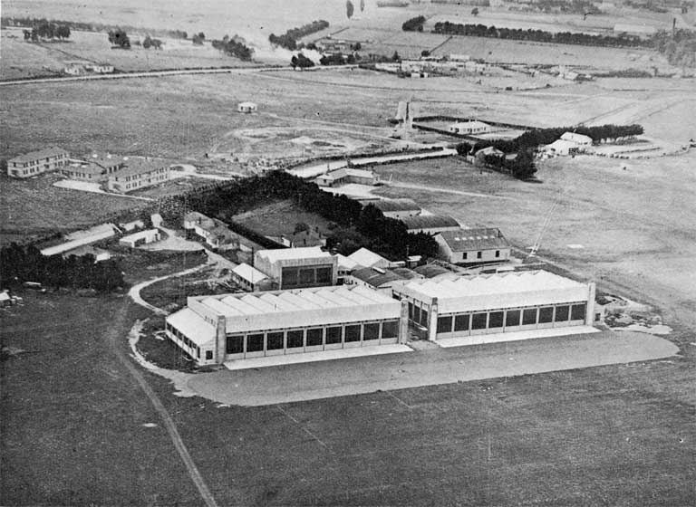
 I have a large version of this here somewhere. As can be seen it is actually earlier. This was labelled 1936 I believe. |
|
|
|
Post by shamus on Sept 30, 2011 17:49:10 GMT 12
Great photos, Baronbeeza. I would love to see any more photos of Wigram at that time.
Especially any around 1935 or earlier if there are any.
|
|
|
|
Post by Dave Homewood on Sept 30, 2011 19:03:37 GMT 12
This is not very good as it's a photo I took of a 1937 newspaper cutting from a scrap book (Sir Ralph Cochrane's scrapbook held in the Air Force Museum of New Zealand archives as it happens! Not sure of the exact date or paper as he didn't keep the details of that on this clipping. It's circa March 1937.)  |
|
|
|
Post by Dave Homewood on Sept 30, 2011 19:15:03 GMT 12
Notice the four little hangars with curved rooves between where the Technical Squadron Hangar was built and the Station headquarters building. These were gone by WWII. I guess they were the original workshops that Tech Sqn hangar replaced?
|
|
|
|
Post by oggie2620 on Oct 1, 2011 8:44:41 GMT 12
Love the pics.
|
|
|
|
Post by Dave Homewood on Oct 1, 2011 11:47:41 GMT 12
I have often wondered, of the three original WWI hangars (one of which with the angled roof rather than curved was obviously a workshop as it didn't have hangar doors) why was the middle one removed? And when? Was it just a necessity for carpark space? Or was there something wrong with the structure? Or was there a fire perhaps?
|
|
|
|
Post by baronbeeza on Oct 1, 2011 11:57:37 GMT 12
My memory is shot Dave, I imagined the one on the left to be the woodwork shop in my time. Next was the Gymnasium and the pool. Was there much else on that side leading down towards MT ?
What did the gym hangar become when the new gym opened in the 80's ?
|
|
|
|
Post by Dave Homewood on Oct 1, 2011 12:05:34 GMT 12
Yhe one with the angle roof on the left was indeed the Chippy shop in my time, I have no idea what was in the right hand hangar in my time. We had a proper gymn by then. I have a feeling it may have been owned by MT by then but not certain. The middle one is the one that was gone and that I was asking about.
|
|
|
|
Post by Dave Homewood on Oct 1, 2011 12:07:31 GMT 12
Actually maybe Stores had that ex-gym hangar? Not sure.
|
|
|
|
Post by baronbeeza on Oct 1, 2011 12:20:17 GMT 12
|
|
|
|
Post by shorty on Oct 1, 2011 13:26:24 GMT 12
I think the opriginal hangar that was removed was just because of general rot and poor condition and the area became a MT park (?)
I am going to the Wigram SNCOs reunion tomorrow night so will ask some of the grim digs then
|
|
|
|
Post by baronbeeza on Oct 1, 2011 15:13:27 GMT 12
If you look at the top pic again you can possibly see lakes or bodies of water. It seems to be not far off the end of the MQ patch along Springs Rd. I knew there was water along Halswell Junction Rd near the roundabout. There was also water further along towards Halswell directly on the approach to seal 03. This is the area now being developed for the new Southern Motorway. I believe the motorway was delayed for a period seeking a solution as was possibly the Ngai Tahu expansion of their housing development. The area between the Southern Taxiway and Awatea Rd has been excavated and turned into drainage ponds. www.ccc.govt.nz/thecouncil/policiesreportsstrategies/areaplans/southwest/whatishappeningintheSWAP.aspx#jumplink2I still have the feeling the land was better utilised as an airfield. |
|
|
|
Post by Dave Homewood on Oct 1, 2011 17:21:19 GMT 12
I guess that's why they called it Springs Road. Apparently there's a very shallow water table under the whole old base. In 2010 they were doing studies on the water table to see if it would affect the new bit of the musuem that is to be built.
|
|
|
|
Post by Dave Homewood on Oct 1, 2011 17:22:21 GMT 12
Actually I meant 2009.
|
|
|
|
Post by shorty on Oct 3, 2011 11:37:58 GMT 12
I spoke last night to the last SNCO i/c MT at Wigram and he said the hangar came down in the 80s and was given to Ferrymead, After its erection ther he said it had blown down in a gale a few years later.
|
|
|
|
Post by baronbeeza on Oct 3, 2011 12:16:43 GMT 12
That would be the old gymnasium hangar Shorty. It seems likely MT only used it for a few years before it was moved.
I think was asking about the first round hangar closest to the Chippy Shop. He has refreshed my memory and I think it was all car parking in that area during my time.
I don't think I ever set foot in the mew gymnasium. It must have been completed in 1986.
hmmmm, - I didn't go into the old one that often either come to think of it.
|
|

