|
|
Post by kiwithrottlejockey on Jul 31, 2012 23:42:57 GMT 12
Post-quake preparedness a priority for townOne of the important lessons from the Canterbury earthquakes has been that the impact
on communities goes far beyond lives saved or lost. JOHN McCRONE reports.The Press | 10:50AM - Saturday, 28 July 2012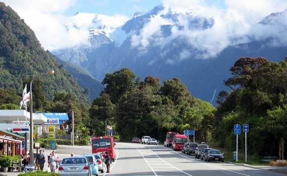 IN THE FIRING LINE: Franz Josef township's main road.WOULD YOU build a petrol station and motel right on top of an earthquake fault? And not just any old crack in the ground, but straddling the magnitude 8 Alpine Fault? IN THE FIRING LINE: Franz Josef township's main road.WOULD YOU build a petrol station and motel right on top of an earthquake fault? And not just any old crack in the ground, but straddling the magnitude 8 Alpine Fault?
Franz Josef township on the West Coast highway must surely take the prize as the single most hazardous spot to live in New Zealand. The Alpine Fault cuts straight through the very centre of this glacier country tourist stopover.
When the fault goes — and it is only a matter of time — the town will literally be ripped in two, the separate halves travelling nine metres in opposite directions at a rate of knots.
Not good news for the Allied service station, Alpine Glacier motel or any of the other buildings sitting directly astride the gap. Nor that great for those built up to its lip, such as the police station that was put up just a few years ago.
So what is Franz Josef to do? Move back a decent distance, entirely relocate, cross its fingers and trust the Alpine Fault holds out for another few generations, making it someone else's problem? The current odds are 30 per cent the fault will rupture in the next 50 years.
The town has of course known for a long time that it is bisected by the fault running the length of the South Island — but anecdotally rather than officially, says GNS Science earthquake hazard expert Robert Langridge.
It has not been written into local maps and planning policies he says, so people have been allowed to continue building across it even during the past 15 years. "I've been on several field trips with a car-load of geologists and we go, ‘Aw yeah, the fault runs right through the petrol station’. And then we kind of chuckle. But on the other hand, we know it's not really acceptable," says Langridge.
The township has some hard decisions to make now that Langridge has delivered a blunt language report about exactly how exposed its residents and visitors actually are.
Langridge says the issues go beyond simply the risk to life if the petrol station is torn apart. After the big one, Franz Josef could be isolated for months by landslips, broken bridges and re-routed rivers.
"In terms of post-disaster preparedness, you've got to have a petrol station that is functioning so that people can get on with filling up their diggers and vehicles." It is serious stuff. And Franz Josef is a microcosm of what is happening throughout New Zealand since the Canterbury earthquakes.
We always knew we lived on the shaky islands, but now the actual experience of a worst case scenario disaster is forcing a re- examination of the hazards to which we may have been guilty of turning a blind eye.
In Tekapo, for example, locals are looking at their sweeping foreshore — a tempting spot for town expansion — and realising that it has been probably carved out by mini-tsunamis, the slopping of the lake, when the Alpine Fault ruptures every 330 years or so.
In Wellington, a new Civil Defence report has pointed out that with just two hilly highways in, the city could be cut off for up to four months by a decent shake.
Christchurch was fortunate in being a flat city, ringed by access roads. Help could arrive from all directions, services could be swiftly reconnected, people and businesses were able to relocate. The same earthquakes in Wellington would likely force a mass evacuation, creating a far more permanent economic devastation. GNS Science's Kelvin Berryman.GNS Science's Kelvin Berryman, manager of the national Natural Hazards Research Platform, says New Zealand has perhaps been rather lulled because it has been so long since a really major destructive event like Napier. GNS Science's Kelvin Berryman.GNS Science's Kelvin Berryman, manager of the national Natural Hazards Research Platform, says New Zealand has perhaps been rather lulled because it has been so long since a really major destructive event like Napier.
"Institutionally, we've probably forgotten some of the lessons because there's been 50 years of fairly benign earthquake activity," he says.
However, scientists like himself now have people's attention. And as the information continues to pour out about what actually happened in Canterbury — how the land behaved, how people responded - the understanding of quake hazards can be that much more fine-tuned.
"To be realistic, the honeymoon period where earthquake hazards are going to be in the front of everybody's minds is going to be very short. We'll be overtaken by other events before long. But at least there's a window of about two or three years to embed some better processes around the country," Berryman says.
The Canterbury earthquakes are certainly still yielding up their secrets.
Canterbury University's head of geology Professor Jarg Pettinga says they will be about the best understood anywhere because in the 1990s a former university seismic engineer, John Berrill, installed a network of ground motion sensors right across Christchurch and out into the surrounding Canterbury Plains.
The network of 30 accelerographs was there waiting to record the Alpine Fault, but ended up perfectly placed to capture everything that has happened over the past two years. So along with the satellite imagery and other evidence, there is a huge volume of data to be analysed and gradually a very detailed picture is emerging.
For instance, says Pettinga, recent 3-D modelling by an Oxford University collaboration has found that the original September 2010 Darfield earthquake was not the result of a single fault, but a chain reaction of some eight fault segments that unzipped in quick succession.
The first to go was a cross-wise section, the Charing Cross Fault, that by itself would have amounted to only about a 6.5 shake.
But this then pressed on the centre of a complex line of fracture — the Greendale Fault — running down from the Canterbury foothills towards Christchurch, triggering a cascade to both east and west which built to a magnitude 7.1 earthquake until either the energy was spent or the faulting was halted by a change in terrain.
Pettinga says the Alpine Fault — the crunching joint between the Pacific and Australian continental plates — is a single frequently polished break. It fractures often enough to be worn smooth. This is why it is possible to point to the individual buildings in Franz Josef which are bang in its firing line.
The Canterbury Plains however are a maze of ancient fissures and folds that get loaded up with the twisting lateral strain the Alpine Fault exerts on the whole east coast of the South Island. The Alpine Fault disperses about 75 per cent of the seismic energy and the other 25 per cent goes into generating local earthquakes.
"Over geologic periods of time, these Canterbury Plain faults will get some width associated with them because they will sometimes rupture on one bit, sometimes on a different plane right next to it." Pettinga says the modelling now suggests the February 22 Port Hills earthquake was produced by a linking up of three fault segments, June 13th's 6.3 was the result of another pair, and then December 23rd's 5.8 off New Brighton Beach was just a single fault.
Pettinga fingers its dotted trace on the map. You can see how last December's is now looking like a seaward continuation of the CBD Fault — the buried line found after a seismic survey last year which alarmingly runs all the way under the central city from Riccarton out to Aranui and New Brighton beach.
This section stirred on Boxing Day 2010 with a sharp 4.9 shake, yet thankfully switched off again following February 22nd. "The rupture of the Port Hills Fault did seem to relieve the stresses in the city area as it has gone dormant since then," says Pettinga.
However, it does appear to have been a narrow escape. "It is looking as though the two sections are lined up — they may be two branches of a historic fault lying quite close to each other, but not quite linked." In hindsight, if both had lit up together, there was the potential for a February-level quake even more directly under tall buildings and centres of population, Pettinga admits.
On a positive note, the energy unleashed by the Darfield earthquake does now seem to have worked itself across Christchurch and safely out into Pegasus Bay, he says. And once any local faults have gone, it will take thousands of years to build up the same levels of strain again.
It is this kind of fine detail about how the land has behaved that is going to be so useful in judging earthquake hazards in the future, Pettinga says.
For example, knowing how the stresses of one quake radiates through the ground to trigger another much further away could well have given Christchurch warning of what was to come after Darfield.
"Because we've got this world-class recording system in place, we've got an incredible record of the seismicity over some 22 months."
"We've captured the aftershock data with a high degree of precision and we can now back- analyse to see whether future stress modelling may allow us to do a much better job in terms of forecasting what will happen over a period of months in a large earthquake event." Probably even more valuable will be the ability to match the strength of shaking to the actual topography of the ground.
Pettinga says one thing learned is the way the aquifer under Christchurch International Airport acted as somewhat of a trampoline shock absorber for that area. And by contrast, how other landscape features, such as the ridgelines of the Port Hills and its loose sediment filled basins, worked to focus the energy of the earthquakes.
A sudden slowing and bunching of the shock waves as they passed from hard rock to unconsolidated gravel was the reason the Heathcote Valley suffered the most off-the-scale ground accelerations in February, says Pettinga.
"In the future, we should be able to identify areas prone to very strong ground shaking due to these kind of particular site effects," he says.
There could be a micro-zoning of a city based on this knowledge, a fine-tuning of building codes that would make New Zealand cities both safer, and also save money because the precautions could be more closely tied to the actual levels of risk.
GNS's Berryman says the Canterbury experience has definitely created some new questions. The cascade effect is one that seismologists want to understand better — especially in relation to the Alpine Fault.
Knowledge about the Alpine Fault itself tightened up recently with the June publication of a paper by a team led by Berryman. The group managed to find a hillside by a creek near Milford Sound that bore the marks of 24 Alpine Fault quakes dating all the way back to 6000BC.
Berryman says this continuous record shows the fault indeed keeps to a remarkably regular schedule. The average time between movements is 330 years, with two-thirds of all the quakes happening within 260 to 400 years.
The smallest gap was just 140 years, the longest stretched out to 510 years. But with the last earthquake taking place in 1717, this is why the current odds of another stands at 30 per cent within the next 50 years.
Berryman says a lot of people's thinking has been focused on the immediate impact of a magnitude 8 earthquake — what it will be like for Queenstown, Franz Josef, Hokitika and others most likely to be hardest hit. But now there is the further worry of the chain reaction that perhaps should be expected.
Depending on which direction the fault breaks, says Berryman, it will load up the landscape with an energy that will have to be dispersed in a series of knock-on events.
"If it ruptures North to South towards Milford Sound, then that's bad news for Fiordland. Most of the forward energy will be directed down there. But if it ruptures from South to North, then it will impose an additional stress to the ends of all the Marlborough faults." So quite possibly, in the same way that the Darfield earthquake has triggered a sequence fanning out into Pegasus Bay, this could cause a succession of large earthquakes through Kaikoura, Blenheim and other areas lasting 40 or 50 years, Berryman says.
The point is not to worry people, but to have good information on which to base decisions. And right now, geologists are not even sure which direction the Alpine Fault normally does break.
Berryman says as much as learning about the way the land reacts, an important lesson from Canterbury has been realising the potential social and business costs of a major event.
He says the old hazard models emphasised saving lives and strengthening individual buildings. Now there is a need to consider the effects on whole communities and the national economy — how to minimise the costs and disruption of a recovery. "It's been a huge wake-up call that has certainly sparked a whole bunch of thinking around economic resilience."
Berryman says such has been the shock of the quakes that in some quarters he is seeing almost an over-reaction. "We've now got some officials worrying about liquefaction and weak soils in their cities where they haven't really got the level of earthquake risk to make it a problem."
Or the fears need some calibration. Wellington has become so dominated by its talk about really big earthquakes, says Berryman, that it is possibly not paying enough attention to the more likely medium-scale ones that would still cause serious disruption.
Likewise, Auckland is thinking about its volcanoes. However, from a risk-modelling point of view, maybe there should be more concern about the virtual certainty of Mount Ruapehu going again sometime soon.
"Ruapehu has an average 20-year return for a 1995 style eruption, and every 100 years you are going to get something even more significant. Imagine the ash coming out of that and a southerly heading towards Auckland. If you had to close down the airport for a long time, the economic impact could be pretty serious."
Yet generally the Canterbury earthquakes are being correctly heeded, says Berryman. He sees changes being made that are building in a preparedness for all kinds of natural hazards.
"Some people may be just thinking about translating ‘earthquake’ all around the country. But it's irrelevant what kind of event it is if it's potentially economy-changing. The resilience implications are much the same whether it's mega-floods, tsunamis, volcanoes or even biosecurity."
So how is Franz Josef going to respond to its own specific dilemma?
Franz Josef Community Forum chair Marcel Fekkes, who runs luxury villas at the entrance to the glacier field, says as you can imagine there are some rather delicate negotiations taking place with the Westland District Council and other local authorities.
The problem is the risks were known, but never properly recognised. "The police station was built only three years ago, but they put that right by the fault line as well." Fekkes says the question now is what kind of solution will be acceptable — and who pays?
Langridge's report suggests a number of options, the most extreme being to abandon the town completely and move its people elsewhere. But a minimum plan is to create a fault avoidance zone (FAZ), a safety corridor some 200 metres wide, and gradually shift people back from the edge.
"It'll be like being red-stickered, but allowed to stay in the buildings," says Fekkes. And town opinions are divided about this.
"Due to events in Christchurch, everyone has got a little more panicky about the risks," he says. Yet faced with the prospect of having their properties blighted without any official recompense, many also would rather the whole subject was quietly dropped. 'For some, the best option is just to forget about it, I think.'
Fekkes says the hope is the local council will eventually accept blame for not preventing development and so come to the table with financial assistance to shift the petrol station and buy out the other properties. 'This whole process could take a couple of years,' he says.
GNS's Langridge says Franz Josef's case is certainly a tough one. But as the ripples from Canterbury's experience continue to spread, he is seeing fewer excuses, a greater willingness to respond to information about New Zealand's natural hazards.
"Yes, people are kind of accepting that what these scientists have been going on about for all these years might actually have something to it now."www.stuff.co.nz/the-press/news/christchurch-earthquake-2011/7367350/Alpine-Fault-poses-threat-to-Franz-Josef
|
|
|
|
Post by skyhawkdon on Aug 1, 2012 7:50:02 GMT 12
Really interesting article.
|
|
|
|
Post by Tony on Aug 1, 2012 22:49:32 GMT 12
Agreed
|
|
|
|
Post by flyjoe180 on Aug 4, 2012 12:06:16 GMT 12
Yep, a good reminder to everyone we are mere passengers on Mother Nature's back.
|
|
|
|
Post by thoram on Aug 13, 2012 18:38:31 GMT 12
 Agreed |
|
|
|
Post by ngatimozart on Aug 14, 2012 13:32:23 GMT 12
Yep, a good reminder to everyone we are mere passengers on Mother Nature's back. I just don't like the way she collects her tickets. Moving me house around all over the place in sudden jerks is not good for the nerves ;D ;D ;D ;D |
|
|
|
Post by kiwithrottlejockey on Aug 18, 2012 22:02:16 GMT 12
Alpine Fault to be mappedBy REBEKAH FRASER - The Greymouth Star | Friday, 17 August 2012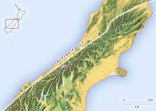 WESTLAND RESIDENTS will soon be able to see exactly where the Alpine Fault cuts through the district. WESTLAND RESIDENTS will soon be able to see exactly where the Alpine Fault cuts through the district.
Maps showing the location of the faultline are being drawn up and should be available through the Westland District Council by the end of next week.
District planner Rebecca Beaumont said about 20 maps covering the entire district would be available as the council moves ahead with a plan to create a fault avoidance zone (FAZ) at Franz Josef Glacier township.
“The proposed plan change, to create the zone, should be notified by the end of next week and the maps will be linked on council’s website.”
The FAZ is being created after surveys showed the faultline runs straight through the Franz Josef Glacier township.
Mrs Beaumont said Franz was the only built-up area in Westland that the fault ran directly through.
“There are one or two other structures that the faultline runs through, but the majority is land.”
The council plans to create the zone with a corridor 120m to 140m either side of the faultline. No new buildings will be allowed to be built within that zone. Existing users could be able to modify their buildings in certain circumstances, but no extensions will be permitted.
Existing residents and businesses within the zone will also not be able to “change or increase in an activity”, meaning that somebody wanting to convert a motel to a cafe, or something similar, could also be turned down.
The FAZ could impact those in the Franz Josef community pushing ahead with an “urban revitalisation” plan.
Franz Inc has developed plans to rejuvenate the village, including suggesting that lightweight single-storey commercial buildings could be built within the zone.
The council strategy committee considered the plans at its quarterly meeting yesterday.
Mrs Beaumont told the committee the plans would be in “potential conflict” with the council’s proposed plan change.
“However, I quite like the idea of a walkway along the faultline, it’s undeveloped and what we are looking for.”
Franz Inc plans also include a new “river gateway” walkway from the town centre to the river, new car parking and a new flight centre, and a “pedestrian precinct” in Cowan Street.
Mayor Maureen Pugh commended the community for the ideas.
“It is great to see that the community has shown leadership in planning for its future.”www.greystar.co.nz/content/alpine-fault-be-mapped
|
|
|
|
Post by kiwithrottlejockey on Aug 29, 2012 14:39:33 GMT 12
Quake-zone plan moves aheadBy REBEKAH FRASER - The Greymouth Star | Monday, 27 August 2012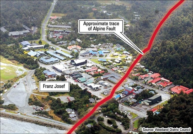 THE ALPINE FAULT may soon restrict where new buildings are able to be erected, as the Westland District Council pushes ahead with plans to create a district-wide ‘fault avoidance zone’. THE ALPINE FAULT may soon restrict where new buildings are able to be erected, as the Westland District Council pushes ahead with plans to create a district-wide ‘fault avoidance zone’.
It hopes to create two new zones along the length of the faultline — one for Westland and a more specific one for Franz Josef Glacier village — as it looks to manage the risk from a fault rupture.
It will see an area of land between 20m and 200m either side of the faultline being blocked out with building restrictions.
Plans for the fault zone, which was created and mapped by the Institute of Geological and Nuclear Sciences, have been released and are now out for public consultation.
The council said an earthquake event on the Alpine Fault would create “a number of significant processes” within Westland.
“Any building or structure affected by fault rupture is likely to suffer considerable damage. This in turn puts lives at risk.”
It will now ask landowners within the general zone to provide additional technical reports in order to establish a more precise location of the faultline.
In the general zone, residential buildings will be discouraged, but agricultural and forestry activities, including buildings not used for residential activities, could be permitted.
The council would also include the zone on its Land Information Memorandum (LIM) reports, and those applying for a building consent within the zone would need to have a statement from a qualified engineer that the building would perform post-fault rupture.
“In the council’s view, this certification may be difficult to obtain.”
It said extensive studies had already been done in Franz Josef Glacier so the faultline mapping was already accurate.
“The rules within this area — the Franz Josef-Waiau fault rupture avoidance zone — are more restrictive.”
No new buildings will be allowed to be built within that zone. Existing users might be able to modify their buildings in certain circumstances, but no extensions will be permitted.
Existing residents and businesses within the zone will also not be able to “change or increase in an activity” — that clause would mean somebody wanting to convert a motel to a cafe, or something similar, could also be turned down.
GNS studies conclude that the probability of an Alpine Fault earthquake event, with fault rupture, occurring is 20% within the next 30 years.
Maps for the entire Westland district showing the location of the fault, are available through the council website. Franz Josef Glacier is the only built-up area through which the fault runs directly.
Submissions on the plan change close on September 24. Submissions received will then be summarised and put out again for consultation, followed by a hearing.www.greystar.co.nz/content/quake-zone-plan-moves-ahead
• Westland District Plan — Maps (7.45MB PDF document)• Mapping And Fault Rupture Avoidance Zonation (2.29MB PDF document)• Planning For A Safer Franz Josef/Waiau Community (1.68MB PDF document)
Franz fears ‘ghetto’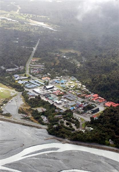 By CHRISTINE LINNELL - The Greymouth Star | Tuesday, 28 August 2012FRANZ JOSEF GLACIER residents fear the West Coast’s main tourist town will become “ghetto-like” if the Westland District Council forges ahead with controversial plans to avoid the Alpine Fault, which runs through the middle of the village. By CHRISTINE LINNELL - The Greymouth Star | Tuesday, 28 August 2012FRANZ JOSEF GLACIER residents fear the West Coast’s main tourist town will become “ghetto-like” if the Westland District Council forges ahead with controversial plans to avoid the Alpine Fault, which runs through the middle of the village.
The council has notified a District Plan change to establish ‘fault rupture avoidance zones’ in areas closest to the faultline. Inside the zones, new building or building expansion would be halted, “due to the risk of human safety”.
The plan change also provides new building zones to the north of the existing township.
Marcel Fekkes, who chairs the business group Franz Inc., said 32 commercial and residential buildings were situated near the faultline.
“People won’t be investing in their properties because their buildings aren’t worth anything any more. It actually does create quite a problem for us.”
The council report says “any building or structure affected by fault rupture is likely to suffer considerable damage” which would put lives in danger.
According to research from GNS Science, Franz Josef village is “by far the largest community” built along the trace of the Alpine Fault, which crosses the town from the north-east to the south-west, including cutting straight through the service station on the main street.
The predicted movement was 8m to 9m horizontally and 1m to 2m vertically.
Council planning and regulatory manager Richard Simpson said the council had made a courageous decision.
“They have received some information, and instead of putting it in the too-hard basket or thinking ‘There’s a whole lot of houses there, what about the poor people,’ they have actually made a decision.”
While residents in Franz Josef seemed upset, most of the feedback from elsewhere in the district regarding the Alpine Fault had been positive. “Information actually provides certainty, and certainty is appreciated.”
But in Franz Josef, Fern Grove Supermarket owner Chris Roy said the proposed restrictions on building renovations would put his business in limbo.
“We’ve already got full architect plans for a whole new supermarket, which would be probably half as big again out the back.”
He spoke regularly to other business owners in the village and they had similar concerns about relocating the town.
He was also concerned that media coverage of the issue would drive away customers, 80% of whom were tourists or visitors.
The plan change was “all a knee-jerk reaction from Christchurch”, Mr Roy said.
“If we do get an earthquake here we’ll get a larger effect sitting on the faultline. But would it actually matter where you move to?
“I don’t think you would be safe on that whole area if we do get what they’re predicting.”
Mr Fekkes said that while he could understand the council needed to follow the GNS Science report, he did not think it was an exact science.
Responding to earlier comments from Mr Simpson that some buildings had “reached their economic life anyway”, he said, “There might be one or two that fit that description, but there’s a lot in there that certainly don’t.”
If the council could not help businesses financially, it should use its contacts in Parliament, he said.
“I think it should be on the council to find those funds for us. One way or another we do need assistance here.”
Meetings with affected parties were being organised this week and early next week. The proposed plan change is open for public submissions until September 24.
Mr Simpson said it was likely the businesses caught in the avoidance zone “are going to be run down” but said it was not the council’s responsibility to provide financial support.
Questioning the importance of the risk zones was “missing the point entirely”, he said.
“It’s the difference between a shaken martini and a stirred martini. Everything that is in the fault hazard avoidance zone is more likely to move and rupture, both horizontally and vertically.”www.greystar.co.nz/content/franz-fears-%E2%80%98ghetto%E2%80%99
|
|
|
|
Post by kiwithrottlejockey on Aug 29, 2012 14:39:57 GMT 12
Editorial: Own up to our faultsThe Press | Wednesday, 29 August 2012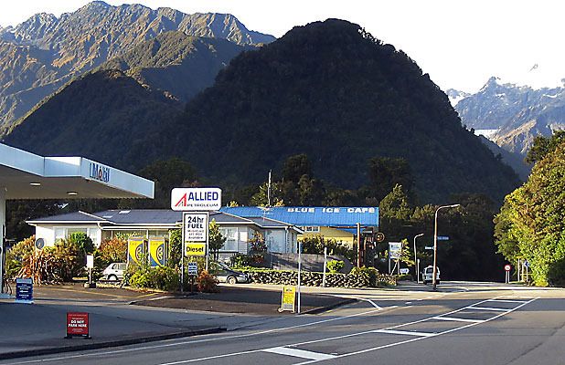 AT CENTRE: The Alpine Fault splits Franz Josef village in two, running through the forecourt AT CENTRE: The Alpine Fault splits Franz Josef village in two, running through the forecourt
of this petrol station and across the main highway. — Photo: PAUL GORMAN.THE fact that the little West Coast town of Franz Josef is built on the Alpine Fault has been known for years. Despite this, people there have managed to put it in the back of their minds and have continued to develop there almost as though the fault did not exist.
Last week that changed with the public notification by the Westland District Council of its intention to alter its district plan to prevent development where the risk is greatest. Critics of the move complain that it will ruin their businesses and sentence the town to a slow decline. That is very likely true but the council's move is merely belated recognition of reality and failure to act would be dangerously complacent.
The district council's plan is recognition of the high risk to the region created by the Alpine Fault. The fault has been marked by large-scale ruptures on a remarkably regular pattern, on average once every 330 years. The last big quake on the fault occurred in 1717 which enables geologists to calculate that there is a roughly 30 per cent chance there will be another major event within the next 50 years. It is a risk that cannot be ignored.
The district council's plan will create two new zones — the Franz Josef/Waiau fault rupture avoidance zone and the general fault rupture avoidance zone. The Franz Josef zone creates a 135-metre-wide swathe through the town where landowners will be able to carry on their existing activities but will be prevented from erecting new buildings, extending their properties or developing new subdivisions.
It is necessary because Franz Josef is right on the fault line. The town's service station, a motel and other buildings sit directly astride the gap. Although geologists, local politicians, residents and others have been aware of the dangers, it has not been written into local maps or planning policies, with the result that building across the fault has continued even during the past 15 years. The police station, put up only a few years ago, is right on the lip of it.
According to two recent GNS Science reports, a rupture of the fault could be expected to move the land up to 9m horizontally and 2m vertically. As Christchurch residents are well aware, movements of that magnitude would be catastrophic.
New Zealand has always been known as a seismically active landscape but the absence until September 4th, 2010, of any large urban tremors since the Napier earthquake in 1931 had enabled it to be treated at the level of mildly flippant remarks about the "shaky isles" and a less than rigorous approach to making buildings that were earthquake resistant.
Complacency had crept in and proved hard to eradicate. Even after September 4th, many objected when the Christchurch City Council tightened the building code to take account of the sharply exposed reality that this is an earthquake-prone country.
Franz Josef is not the only area in which risks that have for too long been ignored are now being properly recognised. Wellington, too, sits on a fault line and new assessments of the hazards created by old buildings are causing dismay to some property owners. The reassessments are unavoidable, however. As Canterbury's experience has shown, the risk does not disappear by being ignored.www.stuff.co.nz/the-press/opinion/editorials/7565436/Editorial-Own-up-to-our-faults
|
|
|
|
Post by Tony on Aug 31, 2012 19:34:07 GMT 12
Severe 5.3 quake strikes West Coast
A 5.3 magnitude earthquake at a depth of just 5km has hit the West Coast.
GeoNet said the 7.38am quake was centred 40km southwest of Haast, and about 10km inland from the fishing port of Jackson Bay.
GNS Science described the earthquake's intensity as severe and reported it had been felt as far afield as Dunedin.
More than 270 people had this morning reported they felt the quake to GeoNet.
Of those, five considered the quake "strong", while 29 thought it was "weak".
The remainder classified the quake under the category "largely observed".
Mary Gray felt the earthquake in Clyde, Central Otago.
"We were still in bed, with our morning tea and the paper when the first quivers started, followed by a definite shaking of several seconds," she said.
"As 'refugees' from Christchurch we're probably super-sensitive to quake movements, and didn't enjoy it one bit!"
Lauren Sleeman said: "It was a decent shake but thankfully not the abrupt, jarring, break-things type, more the big rumble type.
"There is no wind on this beautiful morning here in Wanaka but the trees swayed as if in a wee breeze!"
Eamonnd Johnston, of Johnston Motors, was in his Haast Junction home at the time of the shake.
He described it as "hardly even a wobble".
"It was just a rumble and a rattle and it was over before I realised what it was," he said.
Johnston said it did not cause any damage to his home or the town as far as he knew.
© Fairfax NZ News
|
|
|
|
Post by kiwithrottlejockey on Sept 1, 2012 14:37:02 GMT 12
Hahaha....they're a stoical, unflappable mob at Haast....Haast folk sleep through ‘severe’ earthquakeBy CHRISTINE LINNELL - The Greymouth Star | Friday, 31 August 2012 A 5.3 EARTHQUAKE at Haast this morning that was felt as far away as Dunedin and made national headlines, was viewed as practically a non-event by local residents. A 5.3 EARTHQUAKE at Haast this morning that was felt as far away as Dunedin and made national headlines, was viewed as practically a non-event by local residents.
The quake struck at 7.38am, 40km south-west of Haast at a shallow depth of 5km, according to GeoNet.
GNS described the intensity as “severe”.
It was reportedly felt in Westport, Hokitika, Oamaru and Dunedin.
Hamish Hill said on Twitter: “Wow you could hear that one rolling through the hills in to Arrowtown, shakey (sic) start to the morning.”
But in Haast, residents took it all in their stride, describing it as “short and sharp” — if they felt it at all.
“The cats came screaming inside and a couple of glasses were rattling,” Fantail Cafe owner Aly Brown said. “It was a mild, light shake that went on for a while.”
Lee Rasmussen said, “I heard there was one,” but he was asleep at the time and did not feel much. Nothing fell over or fell off the walls in his house.
Further north at the Waita River, Tony Kerr only found out about the quake when a radio station called to ask him about it.
“We were up, doing our usual thing. I was on the phone to my mother at about 7.30 and didn’t feel anything.”
Others told him later they felt the jolt, but for the most part it was a minor event.
“That’s South Westland for you. We roll with the punches.”
John Duberly, of the Waiatoto River Safari, said: “It was just a jolt, and 10 or 15 seconds after that, a few tremors”.
His double-storey house did not shake much and no pictures came off the walls.
“I didn’t get out of bed, let me put it that way.”
Close to the epicentre, Merv Velenski of Jackson Bay was surprised at the reports of a severe quake.
“Buggered if it felt like 5.3 to me. I’d have said half that.”
“It only lasted a couple of seconds — a bit of a rumble and a bang, and then it was gone.”
“There wasn’t a plate rattled here or nothing.”
He did not notice any large waves in the bay after the quake.
Haast police said no damage had been reported.www.greystar.co.nz/content/haast-folk-sleep-through-%E2%80%98severe%E2%80%99-earthquake
PRELIMINARY EARTHQUAKE REPORT
GNS SCIENCE
GeoNet Data Centre
Lower Hutt, New Zealand
www.geonet.org.nz
The following earthquake has been recorded by GNS Science:
Reference number: 3764993/G
Universal Time: 30 August 2012 at 19:38
NZ Standard Time: Friday, 31 August 2012 at 7:38 am
Latitude, Longitude: 44.10°S, 168.72°E
Location: 40 km south-west of Haast
Focal depth: 5 km
Richter magnitude: 5.3
Web page: www.geonet.org.nz/earthquake/quakes/3764993g.html
|
|
|
|
Post by kiwithrottlejockey on Sept 17, 2012 23:35:04 GMT 12
Franz Josef asks for fault-line compensationONE News - TVNZ | 7:01PM - Monday, 17 September 2012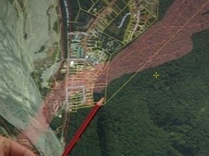 The fault line running beneath Franz Josef. The fault line running beneath Franz Josef.
— ONE News/TVNZ.THE Westland District Council is proposing tough new limits on building development in Franz Josef — a plan that business owners say would penalise them unfairly.
Franz Josef sits astride the South Island's Alpine Fault line and affected business are planning on asking the government for compensation after the exact location of the fault — running under homes, a motel and a petrol station - was mapped.
Richard Simpson from the Westland District Council said: "There is a big risk of the Alpine Fault moving and any building within that fault area will break, will get destroyed and will fall down."
GNS scientists predict there is a 20% chance of the alpine fault rupturing within the next 30 years. If that happens, the ground could shift horizontally by up to nine metres and vertically but up to two metres.
The council is now seeking a ban on future development in areas which are close to the fault.
Simpson said the council was prepared to allow those people who are there already to stay. "But please no more, enough is enough already," he said.
It wants 38 buildings to comply with strict new guidelines, but business owners argue those rules would leave many out of pocket.
Marcel Fekkes from the Franz Josef Development Society said "if you can't do anything to your business then it wont have much value".
Government real estate is also at risk — including the police station and Department of Conservation houses.
Waynne Costello from DOC said they would like to see residents "move away from the zone completely" — a wish shared by affected business owners who want the government to help.
"The community would like to talk to the government to see if we can find a way similar to Christchurch landowners to find compensation for people in the zone," Fekkes said.
But the Ministry for the Environment says there are no compensation provisions under the Resource Management Act.
The town is now considering legal action.• Franz Josef business owners call for compensation (TVNZ On Demand news video clip - 2min 02sec)tvnz.co.nz/national-news/franz-josef-asks-fault-line-compensation-5089325
|
|
|
|
Post by 701driver on Sept 22, 2012 20:37:14 GMT 12
one has to worry at the tekapo" locals" thinking there lake shore was formed by mini tsunamis, they obviously missed the dirty great dam in the middle of town that raised the lake level some 15 metres in the late sixties (or whenever) dont recall any tsunamis since then - damn psudo science
|
|
|
|
Post by ngatimozart on Sept 23, 2012 17:31:06 GMT 12
I know the lake levelof Pukaki was raised twice and it takes around 15 years for the shore level to reach equillibrium. I don't know the history of Tekapo so would have to presume that if there was a pre-existing lake it would have been glacial in origin. Tsunami do occur in lakes and there maybe evidence in the geological record (which is now underneath a lot of water). But the present shorelines of Tekapo and Pukaki are man made, in that the cause was the raising of lake levels to increase electricity production.
|
|
|
|
Post by kiwithrottlejockey on Sept 28, 2012 11:06:53 GMT 12
I know the lake levelof Pukaki was raised twice and it takes around 15 years for the shore level to reach equillibrium. I don't know the history of Tekapo so would have to presume that if there was a pre-existing lake it would have been glacial in origin. Tsunami do occur in lakes and there maybe evidence in the geological record (which is now underneath a lot of water). But the present shorelines of Tekapo and Pukaki are man made, in that the cause was the raising of lake levels to increase electricity production. Lake Tekapo was created as the Godley Glacier retreated after the last ice age. The dead ice that was left behind eventually melted, and voila....Lake Tekapo. If you take a look at the terrain from the air, you can clearly see the remains of the terminal moraine of the Godley Glacier from that last ice-age (you can also see it from the top of Mount John). You can also see the lateral moraine along both sides of the lake. Lake Pukaki was created in the same way when the Tasman Glacier retreated up the valley at the end of the last ice age and left dead ice behind which eventually melted and created the lake. |
|
nzpilot
Leading Aircraftman

Posts: 6
|
Post by nzpilot on Jan 1, 2013 22:21:25 GMT 12
The Blue Ice bar may be buggered, but the Rain Forest bar might be ok ;D
|
|
|
|
Post by kiwithrottlejockey on Apr 11, 2013 12:31:00 GMT 12
Dire quake warning for Alpine FaultBy SHELLEY ROBINSON - The New Zealand Herald | 9:40AM - Wednesday, April 10, 2013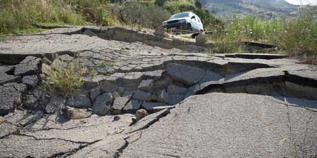 CIVIL DEFENCE officials say there could be up to 10,000 casualties when the Alpine Fault ruptures — and 1000 could be fatal. CIVIL DEFENCE officials say there could be up to 10,000 casualties when the Alpine Fault ruptures — and 1000 could be fatal.
The West Coast would suffer most of those casualties and Christchurch will be relatively unscathed in comparison.
The figures have been revealed by Civil Defence emergency management group leader James Thompson, as Civil Defence, hospitals, police and other emergency services plan for a major exercise to prepare for The Big One.
The Alpine Fault is expected to rupture within 50 years, a one-in-500 year event that will produce a devastating earthquake of a magnitude 8 or more.
Towns and cities throughout the South Island will feel its tremendous power, with those on the West Coast taking most of its brunt.
Settlements and possibly towns are expected to be cut off for long periods because of landslides and wrecked roading and other links.
The predictions come as Civil Defence and emergency services across the South Island wait for the release of a Canterbury University study into the effects of the Alpine fault quake.
It will form the basis of a major South Island-wide Civil Defence exercise on May 29th.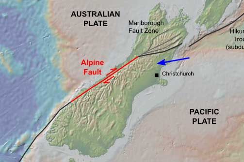 The study is being carried out by Canterbury University geological sciences student, Tom Robinson, who is examining what will happen when the Alpine fault ruptures. The study is being carried out by Canterbury University geological sciences student, Tom Robinson, who is examining what will happen when the Alpine fault ruptures.
The mock disaster has been called "Exercise Te Ripa Hapa" (loosely translated as "Alpine fault earthquake") and will be activated in Marlborough, Nelson-Tasman, West Coast, Canterbury, Southland and Otago.
Mr Thompson said the force of the quake for Christchurch people would be similar to the 7.1 magnitude September 4th, 2010 event.
"It is expected that this would be more of a rolling earthquake which could continue for up to one or two minutes," he said.
Mr Thompson said he would expect serious disruption to roading in Canterbury, including rock falls which would cut off the Arthur's Pass and Lewis Pass with disruption to power and telecommunications.
City council unit manager for Civil Defence Murray Sinclair said he didn't expect building collapses like the February quake in Christchurch, but said unstable rocks on the Port Hills could present a problem.
Mr Thomson said a real rupture of the Alpine Fault was a reality.
"It is always a challenge to do this type of scenario as you don't want to cause alarm bells, but this is a reality. It is a case of not if but when. It is better if we are prepared," he said.www.nzherald.co.nz/nz/news/article.cfm?c_id=1&objectid=10876550
|
|
|
|
Post by ngatimozart on Apr 11, 2013 13:05:32 GMT 12
It's a slip fault as shown on the map and the problem is that it hasn't been slipping for quite a whiles so someone needs to get out there with a huge large can of CRC ;D In the 1960s the then DSIR built a concrete wall over part of it to see how much if nay movement occured, Not a crack on said fence but I was told that their methodology was flawed because any slow movement would bypass wall. These days they use things GPSS etc., which is sub centimetre accuracy, to measure movement.
|
|
|
|
Post by kiwithrottlejockey on Mar 20, 2014 11:35:05 GMT 12
Alpine Fault not so ‘well behaved’By PAUL GORMAN - The Press | 5:00AM - Thursday, 20 March 2014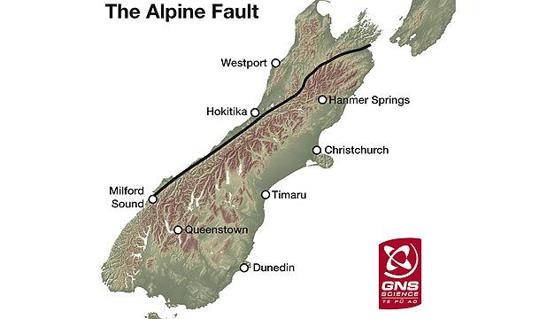 ALPINE FAULT: An 800 kilometre-long fault which runs along the western edge of the Southern Alps ALPINE FAULT: An 800 kilometre-long fault which runs along the western edge of the Southern Alps
from Marlborough to Milford Sound. — GNS Science.THE ALPINE FAULT may have generated more large earthquakes than previously thought, making it increasingly dangerous in future, new research says.
Scientists have traditionally compared the fault to a metronome because of its apparent regularity in causing earthquakes around magnitude 8.0 every 300 years or so on average.
But University of Canterbury researchers have discovered signs that West Coast quakes — mostly blamed on the Alpine Fault — may not be as "well behaved" and regular as assumed.
They found higher "slip release rates" than might be expected based on existing Alpine Fault records, of an average 7.1 metres +/- 2.1m of ground movement in each event, meaning either:
• Moderate to large partial ruptures of the fault, generating quakes of magnitude 6.5 or higher, occur between the "great" magnitude 7.9 or larger quakes; or:
• Some of the quakes previously attributed to the Alpine Fault actually occurred on other faults.
Evidence of offsets along the fault was uncovered in dense bush using lidar (light detection and ranging), which strips away vegetation to reveal the landscape.
The Alpine Fault runs hundreds of kilometres along the western Alps from Marlborough to Milford Sound, where it heads offshore, and marks the Pacific and Australian plate boundary.
Researchers agree the last great Alpine Fault quake of magnitude 8.0-8.2 occurred in 1717, rupturing the ground's surface along more than 300km of the fault.
In comparison, the Greendale Fault that ruptured on September 4th, 2010, is about 30km long.
In light of their findings, another large quake around 1600, previously thought to be another great shake of similar size to 1717, now appears to be a partial rupture of magnitude of 6.5 to 7.0, or was even perhaps from another fault.
The most recent quake causing serious shaking on the Coast was about 1826 of magnitude 7.5.
A major Alpine Fault quake would cause significant damage on the Coast, block road passes for months, destroy infrastructure and generate several minutes of ground motion in Christchurch leading to liquefaction.
The research by Dr Greg De Pascale was published in Geology.
De Pascale's work over four years included periods in thick bush searching for ruptures.
He said lidar data had allowed him and collaborators Associate Professor Mark Quigley and Professor Tim Davies to find features, including streams and rivers, offset by fault movement.
They discovered the 1717 great quake caused about 7.5m of offset over about 380km of the fault. Previous research relied on dating material from trenches dug across the fault, as well as rockfalls and lake records, to estimate the size and year of quakes.
De Pascale said the conclusions were crucial for risk awareness.
"It suggests Alpine Fault quakes may be more frequent than previously suggested and less like clockwork every 300 years or so."
"Previous understanding suggested that after the next major Alpine Fault earthquake we can recover and relax for another, say, 200 to 480 years after the aftershocks cease. Our new findings suggest this may not be the case."
"The next major quake may only be a partial rupture on the Alpine Fault and so there may be another large earthquake following this. This suggests an increased hazard."www.stuff.co.nz/the-press/news/christchurch-earthquake-2011/9846698/Alpine-Fault-not-so-well-behaved
|
|
|
|
Post by kiwithrottlejockey on May 21, 2015 20:07:03 GMT 12
from The Press....Franz Josef earthquake plan gets go aheadBy SARAH-JANE O'CONNOR | 3:51PM - Monday, 18 May 2015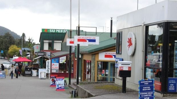 Mapping has shown the Alpine Fault runs directly under some Franz Josef businesses, including Mapping has shown the Alpine Fault runs directly under some Franz Josef businesses, including
the Mobil petrol station, the Helicopter Line offices and part of the supermarket.
— Photo: Sarah-Jane O'Connor.A PLAN to manage earthquake risk in a busy West Coast tourist town has been given the go ahead by commissioners.
Franz Josef is the only town to straddle the Alpine Fault. The Westland District Council has proposed a fault avoidance zone, 100 metres either side of the fault, running through the middle of the town.
Building consents within the zone would have to meet more rigorous standards and changes made to existing buildings would be limited.
Independent commissioners Gary Rae and John Lumsden accepted the change to the district plan, following a hearing in March.
Business owners told the pair they felt they were effectively being red-zoned and feared they would not be compensated if they had to relocate.
The Franz Josef zone includes 30 properties, including the police station, petrol station, supermarket and a motel.
On Monday, the council said commissioners had accepted the plan change with some amendments.
Buildings that had a “low consequence” of failure, such as small storage sheds, fences and in-ground swimming pools, would be exempt.
Prospecting, vegetation clearance and mining activities would not have further restrictions.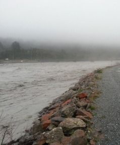 The Waiho River, near Franz Josef, in The Waiho River, near Franz Josef, in
flood in May. Flood-prone businesses
were relocated from its banks in
2003 and compensated.
— Photo: NZTA.The plan change was publicly notified in August 2012 but staffing issues at the council meant progress was delayed.
Westland District Mayor Mike Havill said the Franz Josef community had been waiting for a decision for “some time, so that it can move forward with some certainty”.
Submitters have until June 30th to appeal the decision through the Environment Court.
Geologists estimate the Alpine Fault ruptures on average every 300 years, producing a magnitude 7-8 earthquake when it does. The last time it shook was 298 years ago.
The Helicopter Line general manager Grant Bisset told the commissioners in March that if the science was correct, then a bigger solution was required to manage long-term risk.
Several business owners said compensation should be on offer to help them move out of the zone.
In 2003, local authorities and central government contributed $2 million to relocate flood-prone businesses on the south bank of the Waiho River, on the outskirts of Franz Josef.Related stories:
• ‘Red-sticker’ fears for West Coast town
• Franz Josef locals in limbo over fault plan
• When, not if: Alpine fault could cause 8 metres of movementwww.stuff.co.nz/the-press/news/west-coast/68639125/franz-josef-earthquake-plan-gets-go-ahead
|
|