|
|
Post by Ykato on Nov 21, 2012 13:10:09 GMT 12
|
|
|
|
Post by The Red Baron on Nov 21, 2012 13:24:12 GMT 12
Code Red.....run for the hills.......infact ,No run away from the hills... ;D
|
|
|
|
Post by kiwithrottlejockey on Nov 21, 2012 14:11:57 GMT 12
Mount Tongariro eruptsDozens evacuated from Tongariro trackThe Dominion Post | 1:47PM - Wednesday, 21 November 2012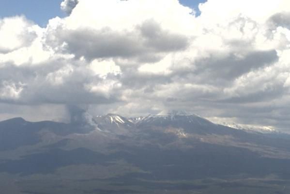 A webcam image of Mount Tongariro at 1.30pm. — Photo: GeoNet.MOUNT TONGARIRO has erupted this afternoon. A webcam image of Mount Tongariro at 1.30pm. — Photo: GeoNet.MOUNT TONGARIRO has erupted this afternoon.
GNS Science confirmed the eruption, at the Te Maari crater, shortly after 1.30pm.
Two bus drivers from Nimon and Sons had reported back to their base that they could see a plume two kilometres high, a spokesman said.
Conservation Department area manager Jonathan Maxwell said 30 to 50 people were being evacuated from the Tongariro Crossing track. No injuries had been reported.
State highways in the area had been closed.
Lake Rotoaira resident Robyn Bennett said there was a big, black ash cloud over her house, which was about a kilometre from the eruption site.
"It's just blew her stack," she said.
She said the air smelled of sulphur.
"It's hard to breathe if you go outside, it's pushing out quite heavily."
Mrs Bennett said she did not hear the eruption.
"It was rather quiet."
She said it looked like a new vent had formed in front of a previous eruption crater.
Ann Lambert, owner of the Rainbow Motel at Tokaanu, near Turangi, said she had not been aware of any noise, unlike the previous time Tongariro erupted, when there had been a "huge loud noise".
"We weren't aware it had happened. We just looked up and saw it," she said.
"It's just a grey cloud at the moment ... It's not as imposing as the last time."
A northerly wind appeared to be blowing the plume away from Lake Taupo and towards the Desert Road.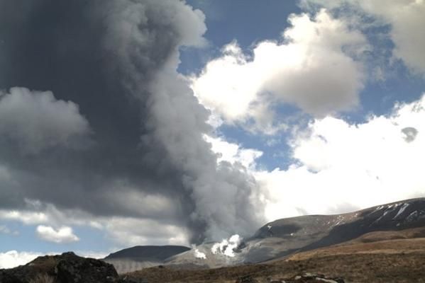 A webcam image of the Te Maari crater at 1.30pm. — Photo: GeoNet. A webcam image of the Te Maari crater at 1.30pm. — Photo: GeoNet.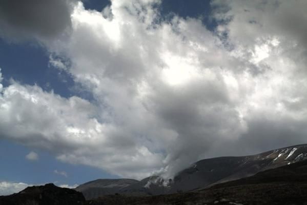 Mount Tongariro, as seen from a webcam at 1pm, about 20 minutes before the eruption. — Photo: GeoNet. Mount Tongariro, as seen from a webcam at 1pm, about 20 minutes before the eruption. — Photo: GeoNet.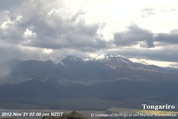 A webcam image of Mount Tongariro at 2pm. — Photo: GeoNet. A webcam image of Mount Tongariro at 2pm. — Photo: GeoNet.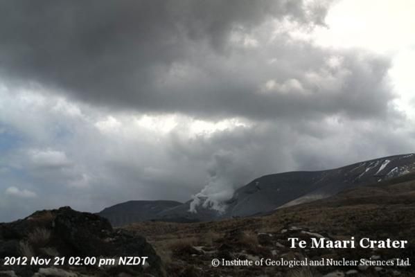 A webcam image of the Te Maari crater at 2pm. — Photo: GeoNet.Wellington Airport spokesman Greg Thomas said no flights had been affected yet, however that could change and the situation was being monitored. A webcam image of the Te Maari crater at 2pm. — Photo: GeoNet.Wellington Airport spokesman Greg Thomas said no flights had been affected yet, however that could change and the situation was being monitored.
GNS Science has updated the alert on Tongariro to 2, meaning there is "minor eruptive activity". It had elevated the aviation colour code to red, however, saying "significant emission of ash" into the atmosphere was likely.
This is Mount Tongariro's second eruption this year. The volcano erupted on August 6th for the first time in more than 100 years.
That eruption widened and deepened the Te Maari crater, and reactivated vents which had been covered up in the 116 years since it last erupted in 1896.
Ruapehu has also been active recently but has not erupted. Pressure was building under the volcano and there was an increased likelihood of an eruption, GNS said last week.
The volcanoes are close to each other but scientists did not believe that the activity at both volcanoes was related.
However, they could not exclude the possibility, GNS vulcanologist Nico Fournier said earlier this week.
"We don't have evidence at the moment that the activity of the two volcanoes are related," Fournier said. "But we can't exclude it entirely."
GNS vulcanologists were researching if activity at the two volcanoes was connected and also were looking at the relationship between earthquakes and volcanic activity.
A series of earthquakes rattled the ground beneath Tongariro in the weeks leading up to the August eruption and another series of quakes have shaken the ground beneath Ruapehu in the past few weeks.• Mount Tongariro information at GeoNet______________________________________ HISTORY OF MOUNT TONGARIRO- 1869: A large eruption (accompanied by an earthquake) formed the upper Te Maari Crater during an explosive eruption. Mâori descriptions include a "bright red flame through the smoke that would burst and fall like snow".
- June 1886: An ash eruption occurred from the Upper Te Maari Crater.
- November 1892: Te Maari again belched forth an immense quantity of steam, mud and boulders; the ejected material rose 2,000—3,000 feet (600—900 metres) before rushing down the mountain side.
- January 1893: Gas emissions were reported, along with two explosions, the second of which ejected pumice.
- November 1896: Until October 1897: an eruption occurred from Upper Te Maari Crater, depositing ash in Napier.
- August 6th, 2012: The volcano erupts for the first time in more than 100 years. It was a gas-driven eruption and created new vents.
www.stuff.co.nz/dominion-post/news/7979520/Mt-Tongariro-erupts
|
|
|
|
Post by ngatimozart on Nov 21, 2012 14:33:34 GMT 12
It's just having a fart  |
|
|
|
Post by TS on Nov 21, 2012 15:31:34 GMT 12
It's just having a fart Everyone and volcano needs to have a good fart every now and then ;D But I reckon she's about to have a goooood rumble, especially if Ruapehu is also rumbling but blocked  |
|
|
|
Post by beagle on Nov 21, 2012 15:57:24 GMT 12
Look out hun, Mt Rolleston is about to blow.......
|
|
|
|
Post by kiwithrottlejockey on Nov 21, 2012 16:12:59 GMT 12
Look out hun, Mt Rolleston is about to blow....... Now that's something I would REALLY like to see.....a mountain created by uplift spitting out a volcanic eruption! ;D Anyway.....here's a map of the ash cloud spread from GNS Science....  |
|
|
|
Post by ErrolC on Nov 21, 2012 17:48:12 GMT 12
Code Red.....run for the hills.......infact ,No run away from the hills... ;D Well in Auckland you would run to the hills - nice solid lava cap that new lava can't get through! |
|
|
|
Post by flyjoe180 on Nov 21, 2012 18:45:59 GMT 12
That's quite a large coverage of ash. No doubt there will be flights affected, particularly at night.
|
|
|
|
Post by flyjoe180 on Nov 21, 2012 19:02:52 GMT 12
|
|
|
|
Post by Bruce on Nov 21, 2012 20:02:15 GMT 12
|
|