|
|
Post by kiwithrottlejockey on Aug 7, 2012 8:23:26 GMT 12
|
|
|
|
Post by kiwithrottlejockey on Aug 7, 2012 8:29:13 GMT 12
Location: Mount Tongariro District: National Alerts 3:10am - 7th August 2012 Volcanic Activity Short description: Volcanic Activity Full description: Just prior to midnight last night the Police Central Communications Centre received a call from a member of the public who reported seeing an eruption on the northern face of Mount Tongariro from his location on SH 46 near Lake Rotoaira West of Rangipo. He described seeing flame like explosions and a cloud of ash coming from 'a new hole in the side of the Mountain.' No reports of injuries or damage has been received to date but a joint agency incident management centre has been established at the Whakapapa Department of Conservation Visitor Centre. GNS Science are monitoring the seismic activity on the Mountain and DOC and Police staff are preparing to check nearby tramping huts at first light. No further volcanic activity on the Mountain has been reported since that initial call to Police. Light ash has been reported falling on SH's 1, and 46 and as far East as SH5 near Te Haroto and onto Napier City itself. Due to possible danger to the public Police have closed SH1 between Rangipo and Waiouru (Desert Road) and SH46 West of Rangipo. SH47 and 4 remain open at his stage as does SH5. Motorists are being advised to avoid travel in the area and these closures will be re-assessed once daylight reveals the extent of the ash cloud and other related safety risks have been assessed. ends You can also view the full details of the alert online at: www.police.govt.nz/news/updates/32361
Location: Mount Tongariro District: National Alerts 5:33am - 7th August 2012 Eruption - Media Briefing Short description: Eruption - Media Briefing Full description: A Media Conference in relation to the earlier eruption on Mount Tongariro will be held at 9.30 am this morning at the Taupo Police Station, Storey Place, Taupo. You can also view the full details of the alert online at: www.police.govt.nz/news/updates/32362 |
|
|
|
Post by flyjoe180 on Aug 7, 2012 10:12:35 GMT 12
|
|
|
|
Post by jonesy on Aug 7, 2012 11:50:59 GMT 12
Draw a straight line between the two.....theres probably a few worried people in the Bay of Plenty!!
|
|
|
|
Post by The Red Baron on Aug 7, 2012 14:37:30 GMT 12
I'm more worried that the Black Caps will never win another Test Match than I am about being blown up by a volcano.
|
|
|
|
Post by jonesy on Aug 7, 2012 15:24:12 GMT 12
I'm more worried that the Black Caps will never win another Test Match than I am about being blown up by a volcano. Depending on where you live the odds may be quite similar.... |
|
|
|
Post by ngatimozart on Aug 7, 2012 16:10:09 GMT 12
More like interesting places. It's because of where we live, on a tectonic plate boundary - the Pacific Ring of Fire in our case. |
|
|
|
Post by Chris F on Aug 7, 2012 16:44:52 GMT 12
Red Baron...on current form the Blackcaps could not beat Ireland in a test...and Ireland are not a Test playing nation.....they have issues too big both on and off the field and big personalities who talk the talk but fail to deliver the goods time and time again.
|
|
|
|
Post by Dave Homewood on Aug 8, 2012 10:23:01 GMT 12
I saw the Black Caps captain tell the media the other day that they were not being consistent. I thought continual loss after loss was consistent. I'll bet they want the earth to open up and swallow them at the end of a match.
|
|
|
|
Post by kiwithrottlejockey on Aug 8, 2012 11:50:07 GMT 12
|
|
|
|
Post by alanw on Aug 8, 2012 19:30:31 GMT 12
More like interesting places. It's because of where we live, on a tectonic plate boundary - the Pacific Ring of Fire in our case. Goes to show we live on a very dynamic planet. ;D ;D I'd rather live here than say an archipelago island group like Japan or Indonesia, where you have Subduction Zones (Trenches), the dynamics in those regions can be literally devestatingly explosive. For example Indonesia and Krakatoa. Japan and Mount Fuji Earth quakes that can occure hundreds of Km's below as two plates converge and diverge that level a city to mere dust. New Zealand though can probably give a pretty good show if wanted, Lake Taupo for example. The Transform fault running through our Southern Alps et al could really give us a real Shake Rattle and Roll  (Quite Similar to the San Andreas fault) If you can imagine a super strong elastic band really stretched and let go. Ouch!!! I have often wondered (probably long after me and my childrens children have gone) what New Zealand would look like as the Australian Plate/ Pacific Plate slowly moves parts of our country North or South. (Transform faults slide by rather than dive) Of interest to me is what the radioactive hotspots are doing under New Zealand, that have caused Tongariro, and White Island to have activity (I live in Auckland and there are some 50 Volcanic cones here ) in other words is it moving North??? "O What a Wonderful World" to quote Louis Armstrong Ol "Satchmo" Regards Alan |
|
|
|
Post by Dave Homewood on Aug 8, 2012 20:10:04 GMT 12
Alan sais, "I have often wondered (probably long after me and my childrens children have gone) what New Zealand would look like as the Australian Plate/ Pacific Plate slowly moves parts of our country North or South."
The bloody inter-island ferry tickets will get dearer and dearer!
|
|
|
|
Post by ngatimozart on Aug 8, 2012 20:20:07 GMT 12
We do have the subduction zones. That's what feeds the North Island Volcanic zones. The only place where the Pacific Plate is not subducting under the Indo Australian Plate is along the South island where they are Transform slippage if I remember the term correctly. It means the plates are sliding alongside each other with the Pacific Plate also being pushed up against the Indo Australian plate. A magnitude of a shake is determined by the verticsl displacment and the length of the rupture, so that was the reason why the Japanese quake of 11/3/2011 was a 9.1. The rupture length was in the order of 400km. It is thought that the Alpine fault has not generated quakes of that size.
Taupo is the most dangerous rhyolitic volcano known to science. It last blew it's stack about 1800 years go and clasts from it have been found on the Chatham Islands. To put its eruption into context the 1883 catastrophic eruption and tsunami from Krakatau (Krakatoa) is a damp squb in comparison or to put in terms we'd understand Taupo is a 15 Megaton nuclear warhead to Krakataus hand grenade. There is a record in the geologic record of a pyroclastic flow, flowing from Taupo over the top of Tongariro (Taupo was a lot higher) with a velocity in excess of Mach 1. Taupo appears to have a habit of blowing itself up every 32,000 years or so. So we're pretty ok at the moment.
|
|
|
|
Post by alanw on Aug 8, 2012 21:31:00 GMT 12
We do have the subduction zones. That's what feeds the North Island Volcanic zones. Yes we do have the Subduction zones, but when you consider where New Zealand sits in relation to the Benioff Subduction Zones covering Japan/Indonesia/Alutians and off the west coast of South America, we have ones that are less inclined than those of the Archipelago type -though still give you one helluva bang when required Transform faults can be devestating enough, just ask any survivors who are still alive from the 1906 earth quake in San Francisco. Obviously the mechanics of a plate divergence and transform sidling are different, but the devestation caused can be just as bad. Volcanoes also have their places in the Boom and destruction factor, and yes Taupo certainly sits up there. Ultra Plinian - about the biggest badest type you could imagine. If any of you remember Mt St Helens and the destruction it caused? Taupo by far exceeded it Man, we kiwi's really do things differently don't we?? |
|
|
|
Post by alanw on Aug 8, 2012 21:41:41 GMT 12
Alan sais, "I have often wondered (probably long after me and my childrens children have gone) what New Zealand would look like as the Australian Plate/ Pacific Plate slowly moves parts of our country North or South." The bloody inter-island ferry tickets will get dearer and dearer! ;D ;D ;D ;D |
|
|
|
Post by flyjoe180 on Aug 9, 2012 10:18:07 GMT 12
A decent enough earthquake pushing the Cook Strait floor up may end any ferry requirement. I recall there was a display at the Auckland War Memorial Museum showing what NZ may look like in millions of years time. That display estimated NZ will become thinner and more elongated, stretching to the north, bending slightly giving the plan view a more 'vertical' look. Now that would make the weather interesting.
|
|
|
|
Post by ngatimozart on Aug 9, 2012 18:40:31 GMT 12
Alan sais, "I have often wondered (probably long after me and my childrens children have gone) what New Zealand would look like as the Australian Plate/ Pacific Plate slowly moves parts of our country North or South." The bloody inter-island ferry tickets will get dearer and dearer! ;D ;D ;D ;D Don't have to wait that long. After the current sea level rise it will drop after the next ice age kicks in so theoretically the Strait should be narrower. Unfortunately the sea level won't drop enough to close the Strait because of deep canyons that run through it. Maybe the 'wet' distance between the North & South Islands will be enough to enable a bridge to be built between the two  |
|
|
|
Post by kiwithrottlejockey on Aug 9, 2012 19:27:29 GMT 12
Or CLICK HERE to view the video-clip in a larger-sized format.
|
|
|
|
Post by kiwithrottlejockey on Aug 9, 2012 19:27:45 GMT 12
|
|
|
|
Post by kiwithrottlejockey on Aug 9, 2012 19:28:03 GMT 12
Tongariro ash plume seen in moonlight satellite imageBy MICHAEL FIELD - Fairfax NZ News | 7:45AM - Thursday, 09 August 2012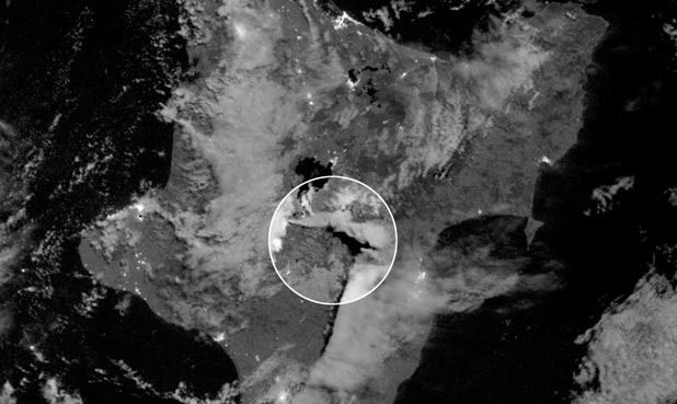 ERUPTION BY MOONLIGHT: The ash plume can be seen in this low-light satellite image. — Picture: NASA.THE ASH CLOUD from Tongariro's midnight eruption this week was caught on camera by a special low-light imaging satellite just an hour after it began. ERUPTION BY MOONLIGHT: The ash plume can be seen in this low-light satellite image. — Picture: NASA.THE ASH CLOUD from Tongariro's midnight eruption this week was caught on camera by a special low-light imaging satellite just an hour after it began.
Nasa released the picture today showing the ash plume at 12.55am on August 07.
It says the image was acquired by the Visible Infrared Imaging Radiometer Suite (VIIRS) on the new Suomi National Polar-Orbiting satellite.
It has a "day-night band" that can detect volcanic ash plumes lit by moonlight alone.
Nasa says the detection of volcanic plumes is useful because ash can endanger airplanes in flight.
"It is interesting to note that the ash downwind was lofted fairly high," said William Straka of the Cooperative Institute for Meteorological Satellite Studies at the University of Wisconsin.
The first appearance of the ash plume occurred far downwind of Tongariro in thermal imagery because ash was lofted high enough to produce a strong thermal contrast in the atmosphere.www.stuff.co.nz/science/7444109/Tongariro-ash-plume-seen-in-moonlight-satellite-image
|
|


 (Quite Similar to the San Andreas fault) If you can imagine a super strong elastic band