|
|
Post by ErrolC on Aug 17, 2015 18:24:33 GMT 12
I heard on the NZ Tech Podcast that Christchurch requires you to make a booking for their parks, and apparently they will only allow one drone at a time!
|
|
|
|
Post by Dave Homewood on Aug 17, 2015 18:40:54 GMT 12
So there goes their wonderful burgeoning sport of drone racing, unless the find private land to do it on.
|
|
|
|
Post by isc on Aug 17, 2015 22:39:37 GMT 12
The model aircraft folk have an area out near Darfield, on private land that would be ideal for "Drone" racing. isc
|
|
|
|
Post by ErrolC on Sept 16, 2015 8:26:04 GMT 12
www.nzherald.co.nz/nz/news/article.cfm?c_id=1&objectid=11513773More drones likely in agriculture industries By Adele Redmond 8:08 AM Wednesday Sep 16, 2015 The Civil Aviation Authority has issued five new 'rule part 102' operating licences. Photo / Grant Morrell New certifications are likely to boost drone use in New Zealand's agriculture industries, say aviation experts. The Civil Aviation Authority has issued five new 'rule part 102' operating licences following a rule change on August 1. Drone operators can now fly at night, over private property and at heights above 120 metres if certified under the updated rules. About 40 drone pilots have already received training for the certification from Helicopter Pilot Training, an aviation school and the second certified operator. "We're supporting them all the way through the 102 certification and I should imagine their businesses will receive their certification in the next month," said chief executive Phil Maguire. The trainees came from real estate backgrounds, but Mr Maguire said mining surveyors and professional photographers had also expressed interest. Yamaha Motors received the first certification under civil aviation rule part 102 on August 1. Business development manager Geoff Lamb said the company's unmanned crop-spraying helicopter had already garnered interest in Taranaki and Tauranga. "We will want to take the machine around those places," Mr Lamb said. "We want to sell in New Zealand so the idea for us is to get our one helicopter out and flying." CAA senior communications advisor Mike Eng said the new certification would likely mean more drone use in agriculture and other industries. Flightworks, a private air charter service, was certified to use drones for chemical spraying and high-resolution mapping. General manager Hamish Kendall said he believed this technology could help the Department of Conservation eradicate harmful weeds. "It's an alternative to abseiling or helicopters, but also one that can access dangerous or steep places such as wetlands or geothermal areas." Mr Kendall said the 102 certification allowed Flightworks to fly close to objects other operators would generally avoid. "The CAA rules don't cover all activities. Instead, you understand the risks and create a system around that. "We designed our way of flying to make sure we can manage those risks," he said. Mr Eng said the new certification allowed operators to bypass "anything in rule part 101" provided applicants can present the CAA with a plan to mitigate potential safety risks. "We might say you don't have to ask for people's consent if you're a responsible operator and we can see you know what you're doing," Mr Eng said. "As the technology matures we think people will be able to make better safety cases." Other licenced operators to date are Incredible Images Ltd in Auckland's Mt. Wellington and Natural Solutions Marine and Terrestrial Ecologists Ltd in Tauranga. - NZME.
|
|
|
|
Post by Dave Homewood on Sept 26, 2015 18:47:48 GMT 12
Near miss between drone and Air NZ flightMICHAEL WRIGHT Last updated 17:39, September 26 2015  ANDY JACKSON/Fairfax NZ ANDY JACKSON/Fairfax NZ
A drone (not pictured) had a near miss with a commercial jet north of Christchurch on Friday.The Civil Aviation Authority (CAA) is investigating after a near miss between a drone and commercial plane near Christchurch. The pilot of an Air New Zealand A320 en route from Christchurch to Auckland reported seeing the "sizeable" red-coloured drone pass close to the aircraft at an altitude of 6000 feet (1800 metres) in air space at Kaiapoi, north of the city, about 5.45pm on Friday. "Based on the information to hand at this time it raises significant safety concerns," CAA director Graeme Harris said. "We are very concerned that pilot appears to have allowed their aircraft to fly in such close proximity to a passenger aircraft. The [drone] should not have been anywhere near the jet. It simply shouldn't have been in that airspace."
Harris urged anyone with information about the drone flight, or its operator, to contact the CAA.
"We don't want a repeat of this incident and want to make sure there is a clear understanding of both the risks and the benefits of flying [drones] in New Zealand skies."
New civil aviation rules that came into effect last month required anyone wanting to fly a drone beyond what is allowed for traditional model aircraft to apply to the CAA for certification.
Thresholds included flying at night, beyond line of sight, or above 400 feet (120m).
Drone owner-operator Bobbie Reeve, who lived at Kairaki, near Kaiapoi, said there was no use for a drone at that altitude.
"I find it pretty hard for somebody to be at 6000 feet.
"Your battery power's going to struggle for a start. And the bigger the drone the less time you've got. If it was a big drone it would probably have about 15 minutes of power."
There was no benefit in filming from a great height, Reeve said, and air quality was an issue.
"There's a lot of vapour in the air when you get to that height."
In a statement, Air New Zealand said a trend of "reckless" drone use was emerging.
"What our pilot believed to be a drone was being operated in and around the flight path but was fortunately spotted by our pilots who ensured the aircraft avoided it," Captain David Morgan said.
"This was reckless behaviour by the drone operator who has so far not had the courage to come forward and address their behaviour with authorities.
"Drones are an emerging issue for airline operators and clearly incidents involving drones are a cause for concern."
Transport Minister Simon Bridges had been briefed about the incident. He said he was satisfied the new rules for drone flights were appropriate.
"Unsafe [drone] flights are unlawful and will be dealt with accordingly."
Police had filed a report on the incident and CAA staff were investigating.
- Stuff
www.stuff.co.nz/travel/travel-troubles/72445255/near-miss-between-drone-and-air-nz-flight
|
|
|
|
Post by isc on Sept 27, 2015 20:43:29 GMT 12
Could it have been a balloon, or something other than a UAV? Not too far north of there, many years ago it was UFOs. isc
|
|
|
|
Post by Ian Warren on Sept 29, 2015 11:58:39 GMT 12
Only a few years back was lasers, now these drones, I had the chance to check out one flying a RC controlled helicopter surveying building a area, they use a large scale model Bell 206, from the ute they had cameras to fly by and an entire TV record setup, I looked up .. looking up you could hardly see the model, it was a good size, fact was they were able to fly it around without watching it, I was only when it returned did the pilot step out from the shelter and land it ... that was 2000 it was impressive.
|
|
|
|
Post by ErrolC on Sept 29, 2015 19:40:03 GMT 12
www.radionz.co.nz/news/national/285489/how-high-can-a-drone-flyHow high can a drone fly? Updated at 4:03 pm on 28 September 2015 The commercial aviation sector is casting doubt on the claim a drone was responsible for a near miss with a commercial plane over Kaiapoi last Friday. drone The pilot of an Air New Zealand plane reported a near-collision with a drone at an altitude of 1800 metres Friday. Aviation New Zealand represents the commercial aviation sector, and chief executive Samantha Sharif said she doubted it was a drone. ...
|
|
|
|
Post by Ian Warren on Sept 29, 2015 22:37:41 GMT 12
How high can a drone fly? ... Today if they have eyes 'cameras' there really is no limit, with the electric and battery range I guess its only going to expand , Its going to really peeve the dedicated model fliers off because they will licence everything making it a more expensive hobby. |
|
|
|
Post by Dave Homewood on Oct 9, 2015 13:09:07 GMT 12
|
|
|
|
Post by isc on Nov 5, 2015 3:59:08 GMT 12
Wee bit OT, tonight's Aljazeera news had a bit about drones in China, they have started a school for drone pilots as the think that 10,000 pilots will be required for agricultural, and other work. Any aircraft over 7 Kg, or flying at over 120M requires a licenced pilot. The course lasts one week, and most of the flight training is on a flight simulator. isc
|
|
|
|
Post by Dave Homewood on Jun 9, 2016 16:15:42 GMT 12
|
|
|
|
Post by Dave Homewood on Jul 30, 2016 20:03:40 GMT 12
This from last week Drone operator told to pay $1000 to charity6:38 pm on 22 July 2016 A Christchurch man has been discharged without conviction in the first prosecution in New Zealand of someone for flying a drone. 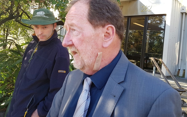 Defence counsel Rupert Glover, left, with his client, Simon Roy Reeve, who has been discharged without conviction for flying a drone without permission in controlled airspace. Photo: RNZ / Rachel Graham Defence counsel Rupert Glover, left, with his client, Simon Roy Reeve, who has been discharged without conviction for flying a drone without permission in controlled airspace. Photo: RNZ / Rachel GrahamIn June, Simon Reeve was found guilty of three charges laid by the Civil Aviation Authority (CAA) after he flew a drone in controlled airspace without permission. Today, in the Christchurch District Court, Judge Gary MacAskill discharged Mr Reeve without conviction, as long as he paid $1000 to a charity of his choice. In January 2015, Mr Reeve had used his drone to film a fire at Pines Beach, north of Christchurch, while a helicopter fighting the fire was nearby. He was found guilty of causing unnecessary endangerment and two charges of flying a drone in a controlled airspace without permission. Judge MacAskill said the offending was at the lower end of the scale, and he was not convinced he needed to use this case to deter other offenders. Mr Reeve told the court that although the drone flew around the smoke up to 1700ft away, he never lost sight of it and it was never near the helicopter. At a judge-alone trial last month, Mr Reeve said he had read the disclaimer document which came with the drone and had a good understanding of aviation laws. The CAA has tightened the rules for drones in recent years after a big jump in numbers, and a drop in prices. Interim rules were introduced in November 2014, followed by new regulations in July last year. Civil Aviation Authority general manager Steve Moore said the case provided a clear signal to drone operators that they needed to follow the rules. Drone operators needed to think of others when their unit was in the sky, he said. Mr Reeve's lawyer, Rupert Glover, agreed the publicity around the case would help others avoid his client's mistakes. "It's given him what he describes as 18 months of sheer hell, and his mother's just said the same to me. They've gone through hell," he said. "They're a Christian law-abiding family who've never done anything deliberately to upset anybody or infringe the rules of society, let alone the law of the land. "They've gone through agonies about this and I'm just extremely relieved for them that it's turned out in an enlightened way." Under the new CAA rules, drones are classified as unmanned aerial vehicles, and users have to have a safety plan in place and consent from the owners of property they are flying over. Those who cannot get consent can still fly a drone if they have an operating certificate from the CAA. Operators also need to have certification from the CAA if a drone is used at night, beyond the line of sight or above 120m. www.radionz.co.nz/news/national/309232/drone-operator-told-to-pay-$1000-to-charity |
|
|
|
Post by Dave Homewood on Aug 25, 2016 17:54:45 GMT 12
Pizza drones are go! Domino's gets NZ drone delivery OK12:00 PM Thursday Aug 25, 2016 Holly Ryan Retail, Innovation and Manufacturing reporter for the NZ Herald  Aerial pizza delivery may sound futuristic but Domino's has been given the green light to test New Zealand pizza delivery via drones. The fast food chain has partnered with drone business Flirtey to launch the first commercial drone delivery service in the world, starting later this year. Domino's Group chief executive and managing director, Don Meij said the company had been investigating innovative and new delivery methods as business had grown. This included looking at robotic delivery, which the government is still considering. Details around where the trial would be held have been kept under wraps - however Domino's said it would use drone delivery alongside its usual delivery methods - and only where it would be faster than the use of a car or scooter. It will offer drone delivery specials at the launch of the trial with plans to extend the dimensions, weight and distance of the deliveries throughout the trial, based on results and customer feedback. The company will not offer the full range of its products for drone delivery - and only those customers within a certain distance from a store will be served from the air. "With the increased number of deliveries we make each year, we were faced with the challenge of ensuring our delivery times continue to decrease and that we strive to offer our customers new and progressive ways of ordering from us," Meij said. "Research into different delivery methods led us to Flirtey. Their success within the airborne delivery space has been impressive and it's something we have wanted to offer our customers," he said. New aviation rules which came into force on August 1 last year allowing and control the use of unmanned aerial vehicles (UAVs or drones) for recreational and commercial purposes in New Zealand. Transport Minister Simon Bridges said the government was continuing to review the laws to ensure New Zealand was at the forefront of the industry. "As Transport Minister I have been actively promoting New Zealand as a test bed for new transport technology trials," Bridges said. "Our enabling laws and regulation means we have the ideal environment to trial all forms of technology." "The trial is also a valuable opportunity for the Civil Aviation Authority, who are making sure that appropriate safety precautions are taken," he said. According to Meij, the company had been investigating delivery options for a while, saying that it didn't make sense to have a two tonne machine delivering a two kilogram order. He said the use of drones offered a faster and safer option as well as removing barriers such as traffic and distance, meaning they could deliver further afield and faster in urban areas. "Domino's is all about providing customers with choice and making customer's lives easier," Meij said. "Adding innovation such as drone deliveries means customers can experience cutting-edge technology and the convenience of having their Supreme pizza delivered via air to their door. This is the future." If it is successful the company plans to extend the delivery method to six other markets - Australia, Belgium, France, The Netherlands, Japan and Germany. Read a Domino's supplied Frequently Asked Questions document on the drone delivery trial here:
|
|
|
|
Post by ZacYates on Aug 25, 2016 18:38:43 GMT 12
So weird.
|
|
|
|
Post by harrysone on Aug 25, 2016 20:01:59 GMT 12
As a Part 102 Operator (Chief Pilot actually) I find it annoying that the media always covers the weird stories re drones/UAVs!
We are trying to use them for real practical applications as a Part 102 Operators with NZ's largest Civil Engineering Consultancy. We use them for surveying (they will cut days off conventional surveys of difficult sites), geotechnical inspections of hazardous sites and emergency response: I was in Christchurch Post-Quake, Nelson Post-flooding event in December 2011, Kawakawa/Kaihu in northland with the SH1 motorway closure and near SH12 (bypass route)closure in 2014,Wellington/Paekakariki Coast post flooding event May 2015.
The really practical applications of Drones or UAVs are always overlooked by the media. These things seriously improve aspects associated with health & saftey as they:
*Provide access to inaccessible/dangerous sites
*Remove initial response teams from the immediate danger (of a slip or cliff collapsing etc)
*They also provide a means for abseilers/response treams etc to actually visualise (via video capture etc), safe site access routes.
Honestly guys these things are fantastic tools in the hands of skilled operators.
I'm getting more than a little tired of hearing all the 'bad news' or 'quirky, stupid' stories about drones in the media, as a result they are always getting a bad wrap as being unsafe/crash prone and the tool of peeping Toms. Unfortunately these are the views conveyed by the public to the CAA which drafted up the deplorable property rules in August 2015. While not a bad thing in itself (it keeps the bloody amateurs from flying dangerously over your head while your walking down the street). It has allowed every blinking authority (usually care of some ignorant silo think tank) finding a means to stop qualified risk-managed Part 102 Operators with aircraft which have been through routine airworthiness inspections operating in their juristiction.
Have a look at some of my outputs, these were created from oblique/vertical images using 'capture through motion' software Pix4D. This software uses point cloud technology...make sure you select HD quality (1080P) in YouTube:
By the way these were all flown in grid patterns at altitudes below 400ft (its the projection of the 3D model which makes it look like I flew them at 1000's of feet).
|
|
|
|
Post by harrysone on Aug 25, 2016 21:31:46 GMT 12
I have been doing this since 2007 (but kept quiet till now). This is some of my work captured on emergency response teams (I'm an Engineering Geologist): Godly Head, near Sumner taken in March 2011. note the cracking in the grass reserve at the top of the cliff, this subsequently collapsed in 2014 and 2016 quakes.  The Gondola at Mt Cavendish, note the recent boulder debris (fresh scars) on the cliff and debris on the road. Post Feb 2011 quake (shot in March)    Nelson flooding/landslide damage in December 2011   |
|
|
|
Post by suthg on Aug 25, 2016 23:14:36 GMT 12
Great quality photos harrysone!! It certainly gives the geologist/geotech guys some safe footage!
|
|
|
|
Post by harrysone on Aug 26, 2016 6:18:25 GMT 12
Thanks, my last post has photo egs shot using my original r/c camera aircraft, a home grown modified fixed wing multiplex easystar foam electric trainer with ailerons, infra red wing levelling system, powerful brushless motor and ability to carry either an oblique or vertical mounted 12mp digital camera. It also carried an altimeter which recorded peak altitude & altitude photos were taken at. I mostly flew with no video downlink, simply flying in left hand orbits to capture the subject worked most of the time. Downlinks through cameras I found provided more of a distraction than an aid at this time. It looks a bit worn at this stage, like granddad's axe the a/c has probably had 3 fuselages and 4 sets of wings  !  Honestly though, The new multi-rotor technology is fantastic and the survey out puts ( the 3d models with control points put in by surveyors) are as accurate as +/- 5cm on the ground. The thing which bugs me is that even the current consumer drones are inherently extremely safe machines. It's the bloody operators which create the problems. Average Joe Blogs who buys these things often has no understanding of things aviation and unlike previous generations of R/c modeller has no interest. Crashes are usually due to the operator not setting proper return to home coordinates, flying too low into objects, people, terrain or ignorantly into controlled airspace. A lack of situational awareness has resulted in return to home flights (when signal lost, this becomes the default safety mode) at altitudes too low & result in collisions with terrain/infrastructure. Honestly there should have been more controls over who can buy and operate thes things, it's too late now the genie has well and truly escaped the bottle! On the flip side new property permission provisos in the new part 101 and part 102 rules regarding airspace rights are inconsistent with NZ (and international for that matter) property laws. According to the regulations, private airspace only includes the land surface and any space 'enjoyed' by the property owner or the structures on them. I'm certain for example it does not give nzta for example the right to prosecute an operator who ventures over a road corridor at 400ft! When asked to define what is meant by 'airspace' 3 prominent experts in CAA could not give me a proper definition of private airspace, the only definitions they had were associated with'public use' danger zones, lfzs, controlled airspace etc. There is a real problem with perceived private airspace rights and I believe that this is likely contestable in a court of law. |
|
|
|
Post by kiwithrottlejockey on Jan 13, 2017 19:13:00 GMT 12
Meanwhile, in Seattle: from The Seattle Times....Drone crashes into Space Needle
during New Year's Eve fireworks setupBy JESSICA LEE | 9:00PM PST - Wednesday, January 11, 2017A FLYING DRONE struck the Space Needle's roof while pyrotechnicians were prepping for the annual fireworks display on New Year's Eve, representatives of the Seattle tower said on Wednesday.
A spokesman for the Seattle Police Department, which is investigating the collision, said such crashes are an increasing concern in the city. The Space Needle incident is the sixth significant investigation involving a drone since summer 2014, according to the department. Space Needle spokesman Dave Mandapat said the New Year's Eve crash was the third one in recent years at the landmark alone.
In that crash, captured in a video by the drone's recording, the drone didn't damage the Needle, Mandapat said. The aircraft sustained some damage, but his team was still able to salvage the footage.
“We looked at the card within the drone to see where it originated and who might be the owner,” he said. About a half-dozen pyrotechnicians were on the roof, which is 575 feet high, when the crash occurred around 2 p.m.
The footage shows a panoramic view of Seattle and the city's waterfront while the drone hovers around the Space Needle, before gaining speed and crashing into the roof.
Mandapat said his team has turned the aircraft over to Seattle police to investigate and has alerted the Federal Aviation Administration (FAA).
Police spokesman Sergeant Sean Whitcomb said the crash marks a “proliferation” of drone incidents.
In June 2014, a woman told police she saw a drone hovering outside her downtown high-rise while she was topless. The drone owner was a Portland-based aerial photographer.
The following month, Space Needle security called police after guests reported seeing a small drone possibly crash into an observation-deck window. There was no damage to the Needle.
At the city's annual 2015 Pride Parade in June, a drone weighing about 2 pounds crashed into a downtown building and then struck a 25-year-old woman in the head. The aircraft's operator in that incident was charged with reckless endangerment.
In November that year, less than two miles away, a flying drone hit the giant Ferris wheel near downtown Seattle's waterfront. No injuries or damages were reported.
According to the FAA, which sets regulations on drones, more than 600,000 operators have registered their drones nationwide in the agency's online-registration system over the past year, the agency reported last month.
Mandapat said crews are frequently on the Needle's roof to ready it for holidays or other occasions. Weighing 3,700 tons, its observation deck sits at 520 feet and hosts more than 1 million people each year, according to its website.
The “T-Mobile New Year's at the Needle” fireworks display lasted roughly 10 minutes, with thousands of fireworks placed at 87 locations on the Space Needle. The annual display has helped Seattleites ring in the New Year for decades.• Information from The Seattle Times archives was included in this report.__________________________________________________________________________ More on this topic from The Seattle Times:
• VIDEO: Drone crashes into Space Needlewww.seattletimes.com/photo-video/video/watch-drone-crashes-into-space-needle-during-new-years-eve-fireworks-setup |
|


 !
!