zkdex
Squadron Leader

Posts: 101
|
Post by zkdex on Apr 8, 2014 16:34:31 GMT 12
World War 2 Emergency Landing Ground. 70 acres in size, construction started 1936/37, carried on through 1937/38; finally graded, levelled, sown in grass and fenced 1938/39.
Coordinates: 38° 24' S, 175° 57' E.
Checked on Google Maps, comes back to an area in Kinleith Forest (partly farm, part forest), northeast of the junction of Flavell Rd and Ongaroto Rd (State Highway 30).
Can anyone confirm better location details, and length of runway(s)?
Cheers.
|
|
|
|
Post by Bruce on Apr 8, 2014 19:26:16 GMT 12
It may be worth noting that at that time of the airfield, Flavell Rd / Tram Rd would have been the Taupo Totara Timber Company's tram line to the sawmill at Mokai (It crossed the Waikato river on an infamously derelict bridge not far from the indicated site. The story goes that the Loco drivers and any passengers got off and walked across the bridge first, the fireman then started the train moving at a snails pace and hopped off and waited until the train had crossed. On the far side the driver re-boarded and stopped the train, to wait for the fireman to walk across afterward...)
I doubt the exact coordinates given as that appears to be in a rough, hilly area with no sign of any levelling. I would suggest South of Ongaroto rd would be the more logical location.
|
|
|
|
Post by suthg on Apr 8, 2014 22:16:27 GMT 12
Thanks Bruce for your research - it prompted me to learn some more about our regional history! Especially of the 82km rail route from Putaruru to the Mokai Sawmill site (The line appeared to close around 1945 or so) If you look at the flat land adjacent to Rt30 right across Tram Rd on the south side, you can get a strip around 1690m long or 5500ft. This would appear to be a much better location for a long air field. This also is seen to be a capable strip based on the original tram railway as indicated here... enzedtransport.blogspot.co.nz/2013_05_01_archive.html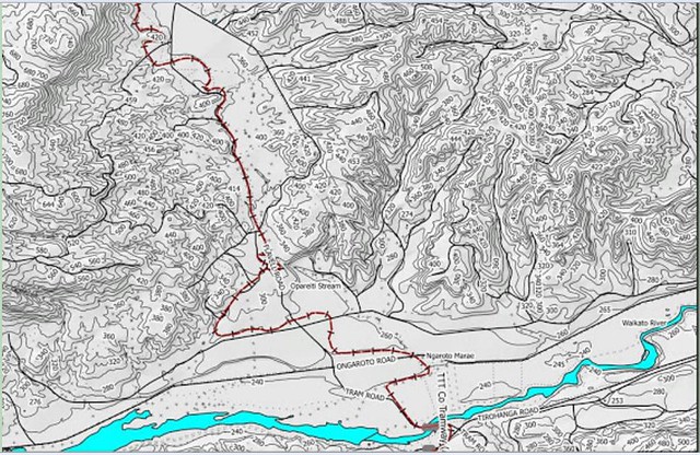 TTTRailLineOngarotoWaikatoCrossing TTTRailLineOngarotoWaikatoCrossing by suthg, on Flickr and compare an overlay of this onto the Google Earth image done by hand, excuse the roughness... 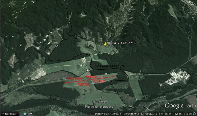 Ongaroto Bridge Rail Route Ongaroto Bridge Rail Route by suthg, on Flickr Which shows a fairly flat region with a possible airstrip across the current Tram Rd - which was not constructed at least until 1950, Kinleith sawmill first ran in 1952. This looks more likely than the rough coords given earlier. note the reference to the Ngaroto Marae in the first image and the railroad path across to it - the Marae is still evident in the Google Earth image. The 1905 bridge was in exactly the same location as the current concrete bridge for Tram Rd. Just my thoughts and research. NB research on this bridge shows an image here... www.ipenz.org.nz/heritage/itemdetail.cfm?itemid=2453 and some history and detail of the bridge construction here... www.timberdesign.org.nz/files/OG-%20Ongaroto%20arch%20bridge1.pdf |
|
|
|
Post by The Red Baron on Apr 8, 2014 22:48:51 GMT 12
I thought Atiamuri was on the land behind the township.Im sure theres an older thread about it. 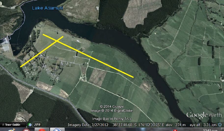 |
|
|
|
Post by suthg on Apr 8, 2014 22:51:35 GMT 12
That would make sense if it was an Atiamuri airfield. I was just trying to find reasonable ground close to the marker coords. Sorry for my misleading images...
G
|
|
zkdex
Squadron Leader
Posts: 101
|
Post by zkdex on Apr 9, 2014 9:39:16 GMT 12
The coordinates quoted are rough, but come from a photograph of a board showing World War 2 airfield locations. It could be that the former airfield is now covered under pine needles!
[As an aside, the coordinates for Galatea were quite accurate!].
Re Atiamuri village, this only began to grow with the hydro electric development from the early 1950's onwards.
|
|
|
|
Post by suthg on Apr 9, 2014 10:10:32 GMT 12
At Atiamuri, there is a great expanse of a flat plateau above the river so the area would have been good for an airfield, although the hill bounds it to the south.
|
|
|
|
Post by thomarse on Apr 9, 2014 12:30:35 GMT 12
Great discussion! I'd never heard of this airfield! How many more are up your sleeve ZKDEX?  My impression of Atiamuri is such that I can't imagine any site for an airfield that would not have high country compromising approaches and departures from/to any direction between North, West and South except way over the Upper Atiamuri side on the road heading for Rotorua. |
|
zkdex
Squadron Leader
Posts: 101
|
Post by zkdex on Apr 9, 2014 12:53:38 GMT 12
I don't have too many more to go, I'm just working through lists of airfields built, as detailed in Public Works Department annual reports from the 1930's.
|
|
|
|
Post by Gary. on Jul 15, 2014 21:09:23 GMT 12
This may help, i know that Gavin Grimmer from findlostaircraft.co.nz has an old map of the Atiamuri airfield in a old airforce training book, i know as i remember him showing it to me,
it had co-ordinates and a sketch of the airfield plus an aerial photograph of it.
I remember at the time he did a google earth search on it and it came up as being planted out in pines now..... maybe give him a yell, i'm sure he would copy you the page from his map book. grgrimmer@inhb.co.nz
|
|
|
|
Post by grgrimmer on Jul 18, 2014 10:28:07 GMT 12
|
|
|
|
Post by suthg on Jul 18, 2014 15:59:04 GMT 12
That puts it close to where I was indicating. I will have a closer look on Google Earth, although I would have thought there was better space on the Atiamuri Plateau cloe to the village.
|
|