Oops, I phrased that wrong - the first concrete runway was indeed laid in the 1940s - 1942 to cope with the heavy bombers, but the subsurface remained very weak.
By the 1950s the runway was literally cracking up under the strain of aircraft 2 - 3 times as heavy as it was constructed to handle. It was constantly under repair, apparently.
Interesting to hear that the runways were completely relaid in the 1980s though - and that there was no arrestor gear until then. It'd be interesting to know how this works - do hooks shoot out of the runway or something to grab onto the plane!?
It's interesting that there is no displaced threshold marked on my 2001 Visual Flight Guide, but the runway lengths usable are 1346m on RWY 03 and 1365m on RWY 21... full length 08/26 - 1581m usable - and 818m of the 1446m RWY 12/30 - now closed (part used as a taxiway for light planes, part completely closed) - was usable at that time.
The plan shows a hill 280ft above the aerodrome 0.95NM from the threshold of then RWY 12 on the extended runway centre line - and also a hill 135m above the aerodrome1.3NM from the threshold of RWY 21, again, on the extended runway centre line.
Noise abatement - good point, and very interesting to hear about the certification process - I assume it was probably certificated back in the civil days.
However, Ohakea is a certificated airfield, - I can only think because it is the only North Island alternate for a Boeing 747 - but there may be some better reason than that.
I imagine that there would be special procedures should Whenuapai return to accepting civil operations.
I wonder a little about the ICAO - but perhaps things have changed over the years.
In 1948, the Tymms report stated:
"Whenuapai can never be made to comply fully with ICAO International Aerodrome safety requirements because of the hills in the immediate vacinity of the aerodrome... these hills not only constitute irremovable flightway obstructions, but also circuit obstructions, and in neither respect can the aerodrome ever be other than substandard."
They also noted that it was possible to extend only one runway to the required length (same unstated, both runway and length!) at a prohibitive cost, and foresaw very accurately that Whenuapai was, and would remain a RNZAF Aerodrome, and that major problems were going to occur if military and civil operations increased above their 1948 level.
Auckland Airport's book (admittedly, utterly biased, and their submission against Whenuapai
was totally biased as well - of course they don't want the competition!!!!)
But they state Whenuapai failed in five key areas - which probably deserve consideration, - if the place is to reopen as a civil airport if and when the RNZAF move out - unless the rules have changed a great deal over the past 50 years, the following problems will remain, and I suspect, make problems certificating the airfield.
* Runways too short, run-offs too steep at each end.
(That one - possibly different as transtasman 737s routinely use the 1900m runways at Palmerston North and Dunedin) - some engineering might be required about the run-offs - as is happening at Wellington.
* Approach obstructions (the aforementioned hill on the approach path)
* Circuit obstructions (the surrounding hills were/?are too high for safe landing approaches and take-off clearance) - note: does Dunedin Momona Airport have similar problems? - VFG says no night VFR circuits unless CGL operative. Would CGL solve or mitigate this problem if installed at and around Whenuapai?
* Side clearances (hangars, control tower, other buildings too close to the edge of the main runway) - ?some demolition and moving might be required
* Meterological factors - apparently - Whenuapai experiences wind/fog/low cloud base and heavy rain more than Mangere.
Any ideas on the above? I'd love to see Whenuapai open as Auckland Airport Mk II (?IATA code WPI!?), if only to teach the Kings Of Greed at Auckland International Airport that monopolies can only be exploited for so long - and for the history, and because it'd be a shame to see a historical airfield - and one fairly well equipped with various lighting and three (six!) runways demolished to make a housing estate or something like that.
None of which are terribly good business reasons! But that was part of the reason to start this project.
Any ideas on the above? I am half expecting someone to tell me rattling off bits and pieces of the VHF shows a little knowledge is a dangerous thing... which it may well be!

It is also of note that the four documented crashes I have read about that happened on or very close to Whenuapai had nothing to do with approach path obstructions, circuit obstructions,
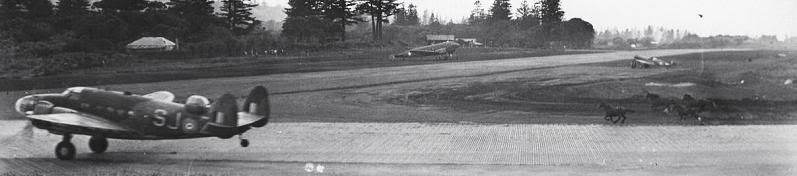
(Accidents: 1942 Hudson - unauthorised low aerobatics, 1943 Boeing B-17 - an apparent engine fire, 1950 - both engines accidently turned off in a C-47, 1965 - a ridiculous manouvre in poor old ZK TEC
Akaroa as documented above).
Hopefully nothing has been left out - the only connection of the aerodrome with the 1949 and 1963 NAC crashes is that the aircraft concerned did
departed from Whenuapai; and both crashes happened many miles from Auckland.
This might be a slightly daft question, like the arrestor gear one above: but could someone tell me how the lights on "distance to go markers" are arranged and what colour(s) they are?
For reference: Lighting for Whenuapai (2001) as follows (interesting that no TCH is marked for RWY 03/21):
HBN FR 1.5NM NW of Aerodrome
RWY 03: LIH ALS/5 BAR W; T-VASIS 3.00 LIH RWY
Distance to go markers lit.
RWY 21: LIH ALS/4 BAR W; T-VASIS 3.00 LIH RWY
Distance to go markers lit.
RWY 08: LIL ALS/1 BAR R; PAPI 3.00/TCH 50 LIH RWY
RWY 21: LIL ALS/7 BAR R; PAPI 3.00/TCH 50 LIH RWY
Aerodrome: ABN FLG W 2.27sec: WDI RWY 03/31
Taxiway: edge. Apron: Floodlighting.
It would be interesting to know how much of that was available back in the forties, fifties, and sixties. I would not be surprised to find only the beacons and maybe LIH RWY were operative...
And what about the VORTAC? I looked it up and found it seems to be the military equipment of VOR/DME...
...and as a tragic note, DME equipment was being installed at Tauranga at the time of the crash of NAC DC3
Hastings and may have prevented the crash, if the pilots had known exactly how far from the airport they were.