|
|
Post by steve on Mar 5, 2007 8:29:52 GMT 12
After seeing those excellent aerial pictures of whenuapai i began to wonder if the outline of seagroves crossing runway are still visable from the air. They were 12 years ago when i last flew over the site with a friend...what about today? The information on this site is excellent except for the location which is some what offcourse. If you want to locate the centre of the airfield just travel down to very end of Seagrove road and there you will find a sizable monument to its presence. Never mind the sign private land. The main runway was longer than ardmores at 5250 feet in length and for those interested the book "Franklin Remembers by Keith and Nona Morris has an excellent chapter about the station including aerial and ground pi :)c of the Dauntless and pilots.
|
|
|
|
Post by Dave Homewood on Mar 5, 2007 11:25:09 GMT 12
Hi Steve,
Yes, I'm aware my map for the location of Seagrove is wrong. I intend to alter it sooner or later. I have the book "Franklin Remembers" which I picked up from TradeMe last year. However it has a sick-making smell about it and it has been airing since I bought it trying to rid the stench. So I haven't been able to bring myself to read it properly yet. It smells of something between stale cigarette smoke and vomit, and makes me wretch if I flick the pages over. Oooh!!
Also my late Dad's cousin, Bob Homewood, recently told me a bit about the aerodrome as he used to go there in the 1950's when it was a popular car racing track. He kindly went out and photographed the area for me which will soon appear on the site when I do the update. I don't know how recognisable from the air it is now, but it looks just like farmland in the photos he took. Then so does Te Pirita in ground level photos but that's very distinctive from above.
|
|
|
|
Post by Peter Lewis on Mar 5, 2007 11:34:03 GMT 12
It is actually within the Auckland International Airport control zone, which makes it a little difficult to get at from the air. (The reason why it is non-operational.) Maybe Joe can go in there at some stage and take a look?
|
|
|
|
Post by steve on Mar 5, 2007 15:00:59 GMT 12
Thanks guys for that info. Apparently few people knew about its existance until after the war and the dauntless were flown for some time by RNZAF over auckland with US markings. I believe the entire squadron at one stage. I first went to the airfield in the late 60s and the runways were very clear except for grass growing through. MOTAT spend many weekends there digging up parts of dauntless according to the owner at the time. At one stage about 15 years ago the tenants at ardmore were interested in redeveloping the site after conflict over rentals. Much of my info was sent to them...plans etc....And Dave ...quite right about the car racing there before ardmore i had forgotten about that post war activity ....I bet a lot of pics were taken by the crowds watching the sport. I coukld be wrong but understand its still a reporting/holding point in the terminal zone?
|
|
|
|
Post by Dave Homewood on Mar 5, 2007 17:26:54 GMT 12
That makes sense to me now about the secrecy of the station and also that their aircraft flew with US markings. My father grew up at Ardmore but he'd never heard of Seagrove at all when I asked him about it about five years ago. It's not too far away from Ardmore and you'd think that they'd have heard something about the place, but it seems it was secret. Also Dad always reckoned that lots of US aircraft would fly in and out of Ardmore. I assumed at first they must have been visiting from US carriers but It was more likely the RNZAf and US Marine Dauntlesses based at Seagrove doing exercises.
|
|
|
|
Post by flyjoe180 on Mar 5, 2007 22:29:28 GMT 12
Show me a map of the exact location guys and I'll try to get some pics on a return flight back to Ardmore. We normally get a clearance not above 1000ft back to AR via Weymouth or Karaka.
|
|
|
|
Post by steve on Mar 6, 2007 14:54:41 GMT 12
Ok... I will do my best as I have misplaced older auckland/northland CAA maps.Map 37 of wises auckland map book year 2000 has the location of seagrove at the end of Seagrove road which was the intersection of the two sealed runways. It is direcly opposite AIA and a radio research station is still there leased on private land with aerials etc. You might now observe the runways at height but from my recent trip there you have to cross fences to find small sections of runway. Out of interest the base of the runway was crushed stone and the "roller towed by tractors to level the stone is still in the vicinity located at the Waiau Pa sports domain at the rear left of the playing fields> The intersecting runways were similar to ardmores but longer by 1000 feet with a much wider angle following exactly the natural contour of the coastline (only 70 odd metres from the harbour)up to Clarks Creek inlet...
Another way of locating the old airfield is to fly directly to the old Kingseat hospital as a landmark as then fly NNW a very short distance over the inlet and you should be overhead with a radio mast on higher ground 300ms from the coastal runways ... good luck!
|
|
|
|
Post by Peter Lewis on Mar 7, 2007 17:43:39 GMT 12
Joe, it's marked as a reporting point on the current VNC sheet 10, in the south sector of the AA CTA to the west of Weymouth. The location seems to be accurate as to the position of the airfield.
|
|
|
|
Post by Bruce on Mar 7, 2007 17:59:31 GMT 12
Heres the appropriate section of chart 10 for those who dont have them - 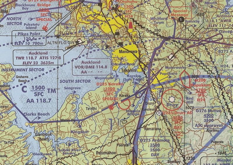 Note Seagrove on the peninsula on the southern shoreline. |
|
|
|
Post by Kereru on Mar 7, 2007 20:35:58 GMT 12
I can remember my dad taking me there to have a look when I was a youngster and him telling me how busy it was during the war. I never knew it was secret. My dad knew the area like the back of his hand being a contractor there before the war and moving out to Matakawau and Waiuku. I only wish I could remember more of his stories. He and his 3 brothers and 1 sister grew up near Patamuhoe on Hunter Road(named after the family) so Seagrove was no secret to them. Dad's younger brother Stan served with the 21st Battalion in the second World War till he got a bullet in the leg at Casino. I can remember as a young lad hearing them talk for hours about the war and their earlier contracting days around that area. I must go back and have another look soon.
I tried Google Earth but can't see much on my computer. It would be interesting to see some nice clear aerial shots of the area.
Colin
|
|
|
|
Post by Peter Lewis on Mar 18, 2007 2:32:53 GMT 12
Heading back up from Tokoroa/Hamilton yesterday, I was able to transit the AA control zone from Te Hihi to Mangere Bridge at 1500' This took me reasonably close to the Seagrove site, and with camera handy I was able to get the following photos of the area. The Tobago, being low wing, is not an ideal camera ship. As I was solo at that stage these were taken one-handed through the canopy. Tracking from the south, this shot gives a general view of the airfield location, with the Awhitu Peninsular on the left, the Waitakere Ranges and the Manukau harbour straight ahead and Auckland International out of the picture off to the right. Seagrove is located within the white rectangle: 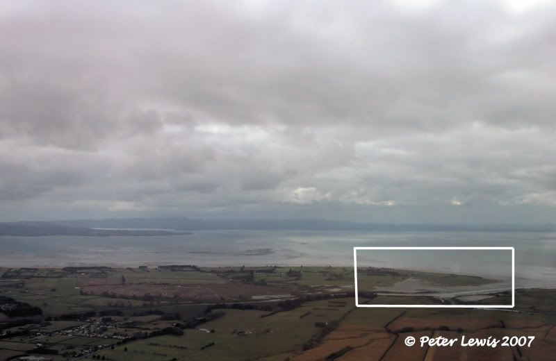 Getting closer, the layout of the runways can still be clearly seen: 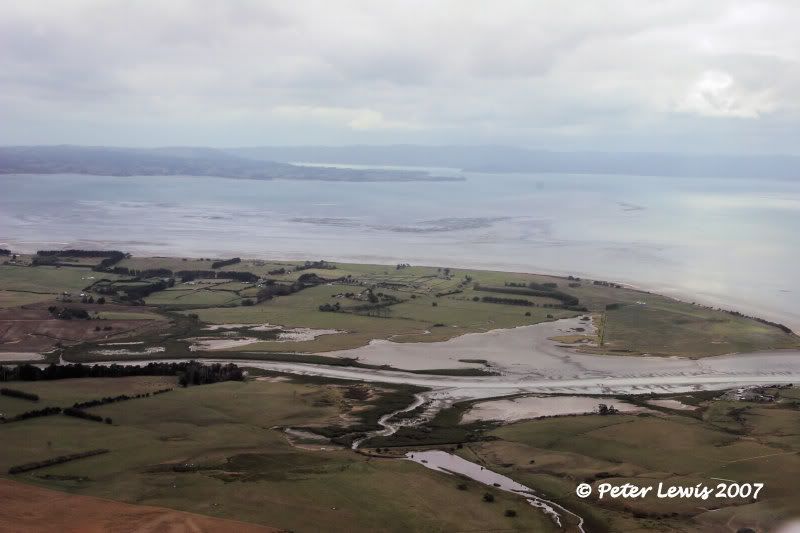 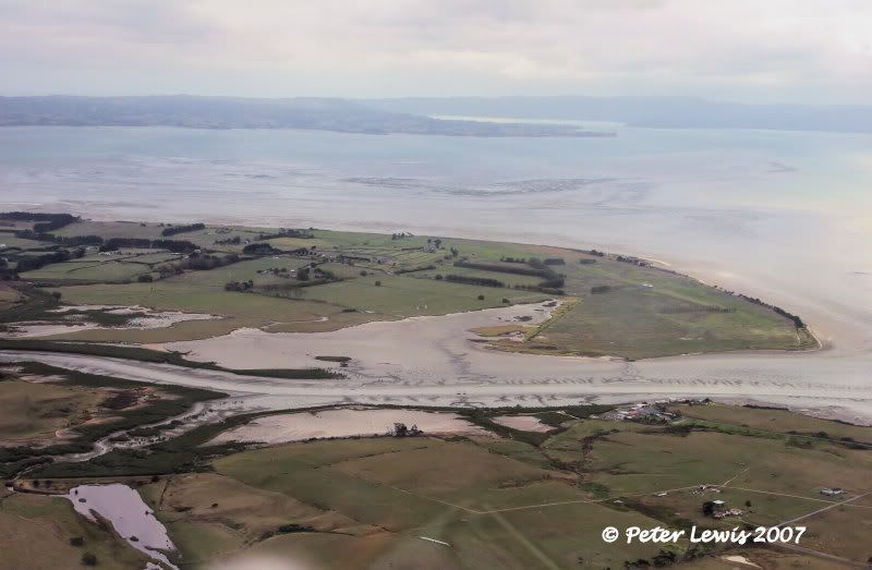 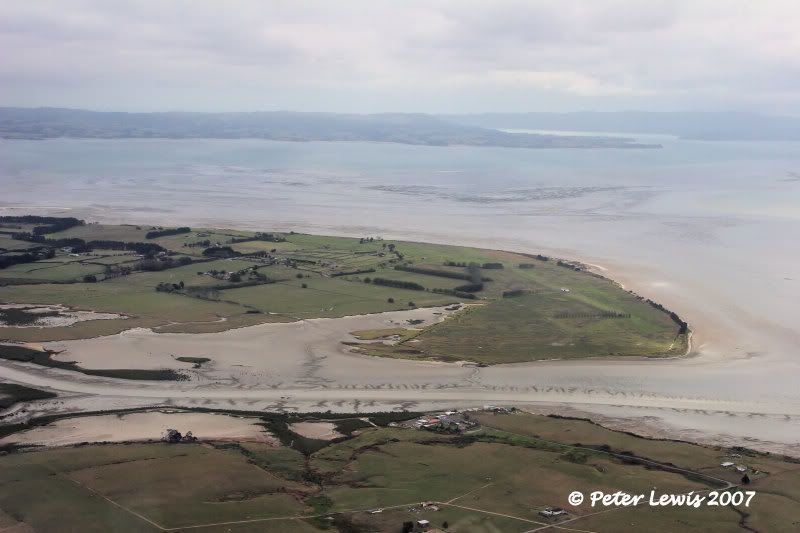 I don't have a copy of the airfield layout at the time, but there seems to be a runway northwest/southeast across the peninsular that now has a building in the middle of it, and a second runway, west/east parallel to the coastline: 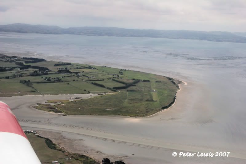 |
|
|
|
Post by flyjoe180 on Mar 18, 2007 8:41:35 GMT 12
Good shots Peter. I havent had the opportunity lately Im sorry, but those pictures are probably better than the ones I would be able to take. Definitely look like old runways in the areas you suggest. Good one handed effort! Shame about the weather though, it's been terrible lately.
|
|
|
|
Post by Dave Homewood on Mar 18, 2007 10:46:21 GMT 12
Great photos Peter. Would you mind if I used them on my webpage? Speaking of which, I was only working on it yesterday regarding the update by the way.
I cannot really see how they fitted a motor racing track in there. There must have been a lot of buildings that have been demolished too. I wonder if there are any wartime aerial shots out there.
|
|
|
|
Post by Peter Lewis on Mar 18, 2007 11:11:54 GMT 12
That's fine Dave, go ahead. I would assume that everything in the way of buildings would have been removed when the station closed down and the area reverted to farmland - don't forget that all building materials were in extremely short supply 1945-1950, so everything would have been in great demand. Many years ago, I browsed through an archive of old Auckland Car Club magazines, and found plenty of references to speed events held at Seagrove, they would have been held around 1950. Presumably there would have been sealed taxiiways that could have been used in conjunction with the runways to create a motor circuit. Also, a number of events were 'sprints', which were just speed in a straight line. Zooming in on that last pic, this is my guess on the runway layout:  |
|
|
|
Post by Dave Homewood on Mar 18, 2007 11:21:07 GMT 12
The track was certainly sealed as my Dad's cousin who was involved with the racing said they moved to Ardmore with races because the seal was breaking up on Seagrove. I assumed the runways were also sealed, I can't recall what Bob said about them.
|
|
|
|
Post by Dave Homewood on Mar 18, 2007 11:23:02 GMT 12
Thanks regarding the photos too, one of these days I'll get it all online.
|
|
|
|
Post by steve on Mar 18, 2007 12:50:36 GMT 12
Excellent photos Peter. I have never seen an up to date picture of seagrove....and this is most likely the first in many years. I have seen in national archieves in Wellington ground pictures of the station but not aerial. Apparently revertments into the hillsides wre used which can still be seen today if you are prepared to track across farm land. There were three on the western runway on one or two on the eastern side. Because the runways were quarried locally from crushed stone they began to crack up as Dave has said. I remember walking down the runways in the late 60s with my brother and the grass was breaking through in most places then. As far as buildings are concerned I understand there were few with the base commanders house (still there ) taken over along with other homesteads in the area. No sign of the radio masts..they seem to have been shifted whatever. The US marines delivered the dauntless some of which were involved in the battle of midway and rather battle worn...and they left within three months handing the base over to RNZAF command.
Correct me if I am wrong but I understand that the base was planned as a larger fighter base for the defence of auckland ...but as the threat of invasion receded plans were changed.
|
|
|
|
Post by Dave Homewood on Mar 18, 2007 17:33:07 GMT 12
Inspired by this thread I have just rewritten what I was working on for the webpage. Here is what i have at the moment. If anyone can add more to the history of the station I'd really appreciate it.
________
RNZAF Station was originally established as a fighter station that would operate in the defence of Auckland City, Auckland Harbour and the regions around. The registered surveyor, Mr Reg Prangley of Mangere, and his assistant Sam Bell, began to survey for the construction of the aerodrome in April 1942. Several trees were removed to complete this.
As mentioned above the proposed station name was changed from Karaka to Seagrove in May 1942. In order to lay the runways, metal chip was sourced from Drury Quarry. Every available tip truck was commandeered for the purpose, with over 60 trucks forming a continuous chain from dawn till dusk, delivering the metal.
In all, six properties were commandeered for the station, and the original area of the land taken for this use was 632 acres. A further 107 acres were later added after deals were negotiated with the landowners.
The land was somewhat swampy, especially so in winter, so networks of drains were dug, tiles and filled in to ensure water didn't lay on the airfield. As the station was right on the seafront, along that perimeter an 8 foot canal was dug along the frontage. The spoils from this trench was used to form a seawall for extra protection.
Accomodation had to be provided for station personnel , and though original plans were for accomodating 250 personnel, this was expanded to 46 Officers, 450 NCO's and Airmen, and 42 WAAF's. So it was to become a reasonable sized station.
Seagrove was a dispersed station, which means that rather than buildings all in one place, the accomodation and workshops, etc., were spread around the station and camouflaged so that from the air they could not be seen. The accomodation huts were all placed beneath large trees. There were eleven huts sized 10' x 8', a further eleven that were 20' x 8' in size, and 35 huts that were 30' x 8' in size. Also there were larger 40' x 24' buildings that were for mess halls, kitchens, recreational buildings and the hospital. So there were a lot of buildings to hide from the air.
Eventually the WAAF's were accommodated in the Seagrove Homestead.
Of course an operational station also needs hangars where aircraft can be maintained. These, and dispersal revetments, were set back into the hills around the airfield, and were camouflaged with wire netting, titree, etc. A headquarters building was built on the rise just above the airstrips and was tied in with an already established farmhouse.
The Seagrove Station Commander's house was a five-bedroomed house down the road with a well established garden, and surrounded with camellia trees. Apart from the runways itself, from the air there was little sign that an RNZAF Station was operating on the Seagrove site, it just looked like farmland.
The construction was completed finally at the end of 1942. The original estimate for establishing the base had been £121,000 but the final bill came in at £225,000.
Some time before the station was complete it had already become operational. No. 15 Squadron had originally formed at RNZAF Station Ohakea, but the squadron had moved up to Seagrove on the 10th of August 1942. The squadron, flying P-40E Kittyhawks, flew in defence of the Auckland region for around two months, before they were posted away, and the newly formed No. 17 Squadron (also flying Kittyhawks) replaced them.
No. 17 Squadron remained at Seagrove from October 1942 through till the 15th of June 1943. At this stage the base of fighter protection for the Auckland region moved from Seagrove to Ardmore.
A new dimension for the station came in May 1943 when American forces arrived in New Zealand. The US Marine Corps dive bomber squadron MAG-14 (Marine Air group 14) was offered the use of Seagrove, having come to New Zealand after their service at Guadalcanal.
MAG-14 remained at Seagrove till July 1943, and during that time as well as this Dauntless squadron, many hundreds of other US aircrew members were stationed at Seagrove whilst on R&R (Rest and Recreation) following service in the Pacific.
When the US squadron left Seagrove they left nine of their Dauntless dive bombers behind, and the RNZAF formed a new unit, No. 25 (Dive Bomber) Squadron, at Seagrove. This squadron was under the command of Sqn Ldr Theo MacLean de Lange, who was appointed to the role on the 30th of June 1943. On arrival he found the station to be sparse and under-equipped, with few tables, and no cooking or eating utensils. The CO's house that he was to occupy had just a double bed, a table and four chairs, with an outside meat safe. Luckily as No. 25 Squadron, which was made up from members of the disbanded Army Co-operation squadrons based at Onerahi and Milson, de Lange's equipment officer, F/O Baker, was able to obtain most of the equipment needed from RNZAF Onerahi which was closing at the same time.
The RNZAF had ordered a quantity of 206 A-24 Banshee dive bombers to equip four new squadrons, No. 25, No. 26, No. 27 and No. 28 Squadrons RNZAF. However these were delayed and then the US service through which Lend Lease acquisitions were made changed from the US Army Air Corps to the US Navy. Thus instead of the army version, the Banshee, the RNZAF was allocated the navy version, the SBD Dauntless.
Whilst that order was to be delivered, 25 Squadron began to train using the nine borrowed war veteran SBD-3's left at Seagrove by the Marine squadron. However it took some time to get the aircraft servicable which probably explains why the USMC left them. The first did not get airborne till the 5th of August 1943.
The crews began flying them but they retained the USMC markings. Then eventually the squadron were to get their own SBD-4 Dauntless which were painted in RNZAF colours.
After 25 Squadron had completed their training, they were ready to depart to Espiritu Santo in the forward area in the Pacific. On the 6th of January 1944 the squadron flew 18 Dauntless in a 'V' formation over Auckland as a farewell flypast. it was the largest formation seen in New Zealand skies till that date. The squadron then did a jungle trainging course at RNZAF Swanson, and they departed Seagrove finally on the 30th of January to fly to Santo aboard an RNZAF C-47 Dakota.
Their aircraft were to remain at Seagrove (they were picking more up waiting for them at Santo), and the next dive bomber squadron, No. 26 was now formed. They too began to train at Seagrove. However both the war situation and the manufacturing situation changed, and the RNZAF decided to scrap plans for the four dive bomber squadrons. No. 26 Squadron had only done a matter of weeks on Dauntless conversion, before they were disbanded and reformed as a Corsair Squadron at Ardmore.
Once No. 26 Squadron was gone, squadrons from nearby Ardmore used the sea just off Seagrove for a firing range for a time, before this was ceased.
The only other training activities I am aware of is Seagrove was the site for a period of one of the Initial Training Wing schools, where new intakes into the RNZAF would learn the basics of RNZAF life before going onto the more specific training courses.
Following the war, it appears that the station has reverted back to farmland although a Radio Research Station remained on site for a number of years. The runways remained there for some years and were used by the Auckland Car Club well into the 1950's as a racing track. However the seal began to break up and the club moved to Ardmore as their motor racing base. Today it is once again private farm land.
|
|
|
|
Post by Dave Homewood on Mar 18, 2007 17:35:28 GMT 12
I meant to add most of the info is sourced from Keith and Nona Morris's book 'Franklyn Remembers' which also draws upon other people's memories within the text. I spoke to Nona some time back and she has given me permission to quote directly from her books, but in this case i haven't as such.
|
|
|
|
Post by steve on Mar 19, 2007 18:37:54 GMT 12
You put all that information together well Dave... I had forgotten about about the number of
wooden army huts on loaction. The only other point worth considering is the runways length I remember both were 5200 feet...Ardmores are 4000` from memory...maybe they were comtemplating larger aircraft?
|
|


