|
|
Post by baronbeeza on May 18, 2014 14:41:28 GMT 12
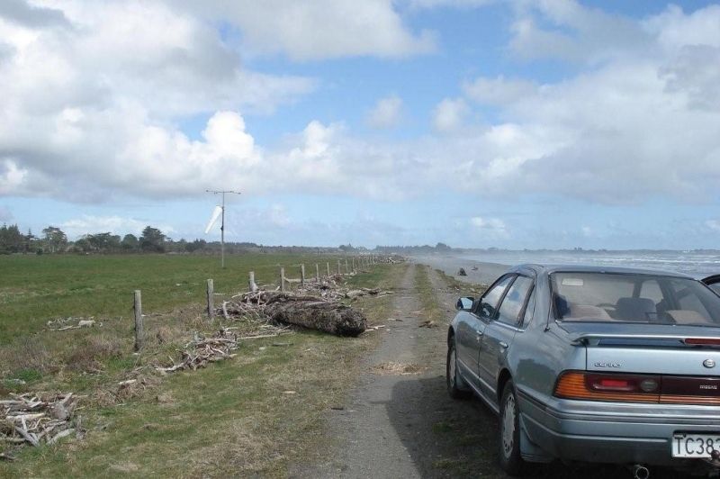
I did a Google view of Birdlings and it didn't work out too well. The surrounding hills are much smaller than those we are seeing in the pic.
While we don't know the time of day he can see the aircraft is facing roughly to the East, possibly South East. That means we are looking out to the West behind the aircraft. I think that is water, either the sea or a lake. The wheel ruts are on an undeveloped strip so we must be able to narrow it down. It has that coastal look and feel so I would be guessing on the East Coast somewhere. Does the ground seem to have a pronounced slope ? Is that a river in the background then ?
|
|
|
|
Post by baz62 on May 18, 2014 14:41:32 GMT 12
Great mystery solved! Damn it now i can't have NZ1007 as 007.......  Needs a bit of panel beating...... |
|
|
|
Post by baronbeeza on May 18, 2014 15:02:20 GMT 12
Lees Valley ?
|
|
|
|
Post by Dave Homewood on May 18, 2014 15:56:13 GMT 12
Where's the Lees Valley? And what RNZAF airfields would there have been there?
|
|
|
|
Post by baronbeeza on May 18, 2014 16:55:18 GMT 12
|
|
|
|
Post by baz62 on May 18, 2014 17:23:28 GMT 12
I landed at an airfield in Lees Valley back in the early to mid 80s so presume it was this one? Oh but no body of water there though.
|
|
|
|
Post by lumpy on May 18, 2014 17:32:52 GMT 12
I did a Google view of Birdlings and it didn't work out too well. The surrounding hills are much smaller than those we are seeing in the pic. While we don't know the time of day he can see the aircraft is facing roughly to the East, possibly South East. That means we are looking out to the West behind the aircraft. I think that is water, either the sea or a lake. The wheel ruts are on an undeveloped strip so we must be able to narrow it down. It has that coastal look and feel so I would be guessing on the East Coast somewhere. Does the ground seem to have a pronounced slope ? Is that a river in the background then ? My earlier suggestion of Lake Grassmere still seems to fit your description of the facts pretty well ( but I honestly have no real idea ) |
|
|
|
Post by baronbeeza on May 18, 2014 17:38:45 GMT 12
Umm, the water had 40 years to drain away....
I think it may have been one of those inland airfields all the same. We are seeing gravel, hills, indeed even snow capped, and I am sure the airfield seems to have a pronounced slope.
The body of water could be a river, it even looks like river flats. We are looking to the West so we could be getting in close to the ranges there. How about off the Arthur's Pass area near Cass ? There are plenty of river flats in that area also.
If you want a Lake then how about around the corner at Lake Sumner, was there an airstrip there that a Harvard could land on ?
That water is not coloured blue on my piccie..
I still fancy my $5 sitting on Lees Valley.
|
|
|
|
Post by Dave Homewood on May 18, 2014 18:49:20 GMT 12
I really don't know what you guys mean by water and gravel. it looks to me like a grass field with a runway crossing it.  The hills/mountains in the background look pretty distinctive and nothing like that photo of Lees Valley if you ask me. perhaps it's in Northland? they have some pretty rugged hills up there.  |
|
|
|
Post by Bruce on May 18, 2014 19:10:08 GMT 12
Conway Flats perhaps?
|
|
|
|
Post by saratoga on May 18, 2014 20:08:59 GMT 12
Must have been a very heavily stocked grass field,there is no sign of a blade of grass,only a lumpy surface and what looks like small rocks(in the foreground).
Though guess they could be animal droppings!
|
|
|
|
Post by Dave Homewood on May 18, 2014 23:13:24 GMT 12
The ground does look like soft soil and the "rocks" are probably clods kicked up by the vehicle that made those tracks. Or could it be a black sand beach? Probably not.
|
|
|
|
Post by baronbeeza on May 18, 2014 23:47:25 GMT 12
oh, a black sand beach and a runway crossing in the background. There are not too many beaches with their own runway.  I still fancy Lees Valley, the view out towards the West in some of those pics was very similar. It could be one of the various Blenheim satellites also. NZ is a pretty small country so we should be able to work this one out ok. |
|
|
|
Post by Dave Homewood on May 19, 2014 0:50:26 GMT 12
Although I cannot see any water in the photo, I think when you compare photos of Lake Grasmere's backdrop with the pointy peaks in the mountains with this Harvard photo, I think Grant is correct. My money is on Lake Grasmere airfield. Unlike Lees Valley it was actually used regularly by the RNZAF for training. www.adventureguide.co.nz/articles/12/8/lake-grasmere.php |
|
|
|
Post by suthg on May 19, 2014 9:22:28 GMT 12
Is it possibly Kaikoura way, the general landscape looks like it.
|
|
|
|
Post by NZ1009 on May 19, 2014 10:04:24 GMT 12
It is a little confusing as there is a Lake Grasmere (near Cass) and a Lake Grassmere (near Seddon) but the spelling varies. I always thought the one used a lot by the RNZAF (mainly by aircraft from Woodbourne) was the Lake Grassmere near Seddon. This URL (http://www.nzrifle.com/ml_nelson_marlborough.htm) gives some information on it. I would think the photo of NZ1001 was taken at the airfield at Lake Grassmere near Seddon as the background hills seem to have similar shapes.
|
|
|
|
Post by baronbeeza on May 19, 2014 11:15:40 GMT 12
Yep, I can go along with all that. We will work it out. Google can be a great tool and the landscape wont't have changed too much. I don't think we should confine the search to 'established' airfields though. It could be any suitable landing site and even moreso if it was worthy of a photo.
There is nothing in the background to indicate this is an airfield, it could even be a paddock.
RNZAF aircraft operated out of most airfields in NZ and some other strange places to boot. I have previously mentioned the Devon that landed at Cronodon. (Reefton). I am sure Lees Valley was used while I was at Wigram but that was after the Harvards, hmm also a little later than 1942 or whenever the pic was taken.
|
|
|
|
Post by Dave Homewood on May 19, 2014 11:28:22 GMT 12
Oh. I never knew there were two lakes with practically the same name and thought I was looking at the Marlborough one. It's like all the Lake Rotoroas around the country. Why can't the map people sort that shit out before worrying about the spelling of HWanganui...
|
|
|
|
Post by davidd on May 19, 2014 20:34:23 GMT 12
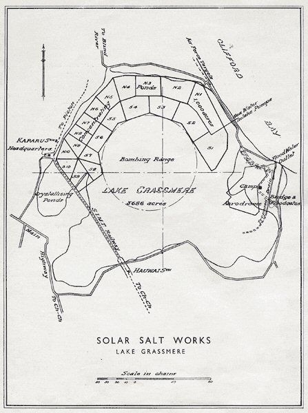
I am almost certain the mystery field is Lake Grassmere (also known originally as Cape Campbell for obvious reasons), which was one of the pre-war government-built airfields along the main trunk route as an emergency landing ground for airliners, like Paraparaumu, Conway, Clarence, Waianakarua, etc. I do have a small map of Grassmere, but there is no photo included in the Air Pilot I have (dated 1946). However there are what appear in the drawing to be some clipped off spurs (wave erosion?) which could well be the unusual cliffs in background of the first photo of the mystery field. I am certain I have seen those unusual cliffs in background of photos before, although I have not actually stood ion Grassmere. However I was very near it about a year ago when I drove out behind the Salt works.
Also the field where NZ1001 came to grief was Norwood, and NOT Harewood, although the latter name is frequently (and incorrectly) associated with this accident - this is the reason that the background of that shot, with the straggly gum trees does not look like Harewood.
As for Lees Valley, I could be wrong, but this dates back, so far as I know, to the late 1950s or 1960s, and was certainly never an RNZAF landing ground (at least not an official one), nor an emergency one either. The Canterbuty Aero Club was certainly using it in 1970s, and I remember one of their Cherokees was lost between Harewood and the Valley at about that time, 2 killed I think.
David D
|
|
|
|
Post by NZ1009 on May 19, 2014 22:00:32 GMT 12
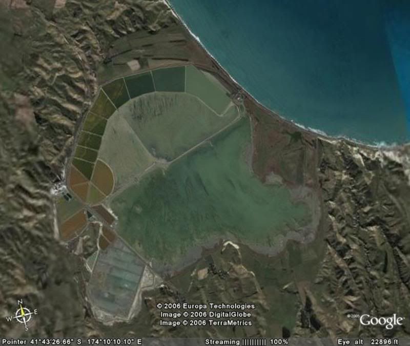
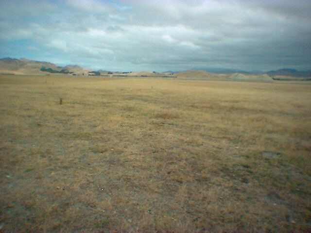
The following are from the website at : www.nzrifle.com/ml_nelson_marlborough.htmA 1941 map:  Google satellite image:  Looking along the runway at Grassmere ( a couple of interesting hills in the background) :  |
|


