|
|
Post by suthg on Jan 4, 2013 20:42:53 GMT 12
Can anyone confirm the use of DC3's (or similar) for topdressing the region en masse in the 50's. There was a long flat airstrip created on top of a plateau hill with about a 5deg gradient on it. It is about 120m wide and 800m long (guess, it's now two paddocks).
I guess I need to go to our library and perform a search on the topic, but was just wondering. The region was being developed for returning vets from WWII and posts in the Pacific - balloted farms. The forest was just beginning to be milled in 1952 and the construction at the Kinleith pulpmill was underway with the sawmill already producing sawn timber.
I am living in one of those homesteads - it was built in Rotorua in the 30's and transported here in three pieces and redecorated in 1952 (under lino was NZ Herald of Oct 52.) This house, now part of a subdivision created in 1967 when Andy Marshall-Inman retired from farmwork (what arm of NZ Forces was he in?). I think the farm was about 500acres for dairying.
Thanks
Graeme
|
|
|
|
Post by The Red Baron on Jan 7, 2013 16:33:02 GMT 12
1950's there was only 1 DC-3 working in the area and that was James's,if it was topdressing around Tokoroa it would have most likely operated out of Rotorua.
Early '50s they would have been dragging a fertiliser spreader behind a bulldozer.
Mid 1950's there would have been lots of Tiger Moths operating and later in the 1950's lots of Fletchers.
James,Robertson and Adastra would have been the licensed operators for the area.
Dave Starr should be able to say if the DC-3 did much work down there.
|
|
|
|
Post by suthg on Jan 7, 2013 16:47:52 GMT 12
Thanks - I am making headway locally asking both those in aviation and the older folk. I don't think the airstrip was long enough for the heavy weights and it may have been more the 60's before they used it. There was talk of a French style plane Socata Rallye possibly with a Lycoming 240 being used - not sure if it was locally owned or what. Any info on this type of plane in Waikato? Apparently a lot of local farmers borrowed the strip for local application as a Boron deficiency really affected the stock condition (Bush Sickness) plus the soil is quite acidic. I have been in contact with Dave Starr and he didn't think that any James DC3 came over here... I should go up there tonight and measure the strip with my racing bike... LOL! A local friend in the SAA shared some info. Thanks for the info RB, I have yet to go to the Library but they had no knowledge of a book discussing topdressing in the district when I spoke with them over the phone. I'll slowly get some info together  |
|
|
|
Post by The Red Baron on Jan 8, 2013 11:04:57 GMT 12
The Rallye ZK-CBX would have belonged to Waikato Flying School,they did flight instruction off local topdressing strips.My Dad learned to fly with them when we lived at Litchfield in the early '60s.I can remember going to a local topdressing strip while he had lessons.Even had a few rides in the back seat.
Jack Bindon owned Waikato Flying School,he would go wherever the pupils were.
Most farmers around there also added cobalt to combat 'sleeping sickness',the cockie would chuck a spoonful in each loader bucket.
Also if you have a look on youtube theres a video called 'Pumice Lands" shows them breaking in the land around Rotorua in the same time period.
To measure an airstrip go to Google Earth,they have a measuring stick.
The airstrip you refer to isnt the one beside the water tower on the hill coming into Tokoroa?.
|
|
|
|
Post by suthg on Jan 8, 2013 13:25:17 GMT 12
Yes, that is the strip I was looking at - as you can see it is probably only about 350m long or so and graded properly with a good width. So that explains that plane arriving there - for private flying lessons locally!
I will go up there tonight and step it out but the google gauge marker may be adequate enough anyway!
That hill used to be owned by the Mossop family and then by a Mr Ken Ashworth. For a while it was known as Mossop Hill and then I guess the Council purchased part of it for the water towers/tanks and there is also a large Telecom Cell tower to the norwest, a Vodafone tower adjacent to them and a police antenna there too. I think there may even be a Mighty River Power repeater there too. The airstrip is now owned by two neighbours, spilt across the middle... Google indicates about 340m. No fence on the north west end, just drops away...
The town is blessed with quite a good airstrip put in place by NZFP - 3640ft (1110m) grassed and 850m sealed. The RC jet boys use it regularly too - like this last weekend.
I now have some contacts to ask about who did the topdressing (Company) and then on to what planes may have been used.
|
|
|
|
Post by suthg on Jan 8, 2013 13:42:25 GMT 12
OK, I have used Google and created an image for the airstrip. Attachments:
|
|
|
|
Post by The Red Baron on Jan 8, 2013 13:54:31 GMT 12
502 metres on Google earth.That strip was used a lot before Amisfield.The only other one was the airstrip at the mill,but NZFP were a bit septic if outsiders used it. 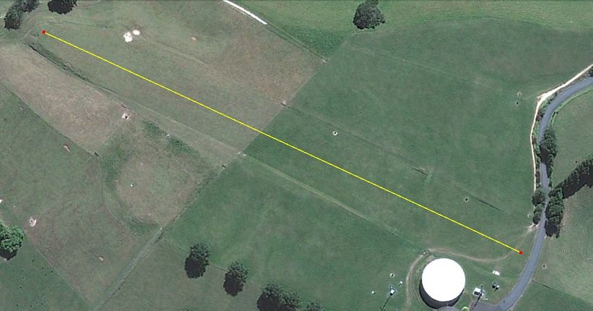 |
|