|
|
Post by McFly on Dec 4, 2020 18:29:21 GMT 12
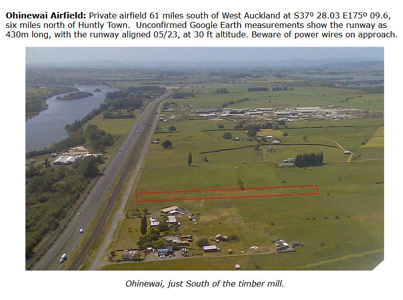
Anyone know if the airstrip in Ōhinewai (lumsden rd), located at -37.467167, 175.160000 (click on the lat/long) is still around? It's supposed to be aligned 05/23 and shows up on most maps, but some don't show it. I briefly investigated the area myself after Black Sands 2020, but I was exhausted after being on my feet for so long so I feel like I may have missed it.  |
|
|
|
Post by Bruce on Dec 7, 2020 10:39:35 GMT 12
Anyone know if the airstrip in Ōhinewai (lumsden rd), located at -37.467167, 175.160000 (click on the lat/long) is still around? It's supposed to be aligned 05/23 and shows up on most maps, but some don't show it. I briefly investigated the area myself after Black Sands 2020, but I was exhausted after being on my feet for so long so I feel like I may have missed it.  I'm pretty certain the Ohinewai strip isnt active any more. Its easily visible from the expressway and there used to be windsocks at both ends, and marker flags beside the power lines. Nothing like that visible last time I went by. |
|
|
|
Post by starr on Dec 7, 2020 13:26:32 GMT 12
Look on other side of highway closer to Huntly.
|
|
|
|
Post by simonlowther on Dec 7, 2020 22:55:55 GMT 12
Anyone know if the airstrip in Ōhinewai (lumsden rd), located at -37.467167, 175.160000 (click on the lat/long) is still around? It's supposed to be aligned 05/23 and shows up on most maps, but some don't show it. I briefly investigated the area myself after Black Sands 2020, but I was exhausted after being on my feet for so long so I feel like I may have missed it. Yes, I have landed a GROB twin astir on that strip in the mid 90s. It had a bantam in the hangar, and flags on the power wires at the western end. The wings of the glider only just cleared a row of waratahs that were keeping the cows off the strip.
I have driven past a few times in the last few years and it certainly does not look flyable any more from the road. Looks like all flying activity ceased sometime back.
|
|
|
|
Post by Luis 'ᚭᛋᛒᛁᛅᚱᚾ' Rozas on Dec 15, 2020 15:49:03 GMT 12
Look on other side of highway closer to Huntly. Do you mean the one located at 37°29'58.5"S 175°09'48.9"E who's runway is clearly visible from State Highway One? |
|
|
|
Post by starr on Dec 15, 2020 20:23:14 GMT 12
Thats the one.
|
|
|
|
Post by Luis 'ᚭᛋᛒᛁᛅᚱᚾ' Rozas on Apr 5, 2021 21:31:50 GMT 12
Well, I can finally say that the airstrip on Lumsden Rd is most likely very gone. On my way to the Bush Tramway Club I decided to look at the area where it should be from State Highway 1. All I saw was a paddock with a very damaged windsock.
|
|


